National Register of Historic Places listings in Smyth County, Virginia
This is a list of the National Register of Historic Places listings in Smyth County, Virginia.
This is intended to be a complete list of the properties and districts on the National Register of Historic Places in Smyth County, Virginia, United States. The locations of National Register properties and districts for which the latitude and longitude coordinates are included below, may be seen in an online map.[1]
There are 24 properties and districts listed on the National Register in the county.
This National Park Service list is complete through NPS recent listings posted May 24, 2024.[2]
Map all coordinates using OpenStreetMap
Download coordinates as:
- KML
- GPX (all coordinates)
- GPX (primary coordinates)
- GPX (secondary coordinates)
Current listings
| [3] | Name on the Register[4] | Image | Date listed[5] | Location | City or town | Description |
|---|---|---|---|---|---|---|
| 1 | Aspenvale Cemetery |  | December 5, 1980 (#80004226) | Off U.S. Route 11 36°48′53″N 81°38′25″W / 36.814722°N 81.640278°W / 36.814722; -81.640278 (Aspenvale Cemetery) | Seven Mile Ford | |
| 2 | A.C. Beatie House | 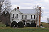 | July 5, 2001 (#01000697) | 249 W. U.S. Route 11 36°47′55″N 81°41′04″W / 36.798611°N 81.684444°W / 36.798611; -81.684444 (A.C. Beatie House) | Chilhowie | |
| 3 | H.L. Bonham House |  | May 11, 2000 (#00000485) | 408 White Top Rd. 36°47′43″N 81°40′53″W / 36.795278°N 81.681389°W / 36.795278; -81.681389 (H.L. Bonham House) | Chilhowie | |
| 4 | Chilhowie Methodist Episcopal Church |  | July 3, 1991 (#91000830) | 501 Old Stage Rd. 36°48′09″N 81°40′55″W / 36.802500°N 81.681944°W / 36.802500; -81.681944 (Chilhowie Methodist Episcopal Church) | Chilhowie | |
| 5 | Downtown Chilhowie Historic District | 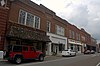 | February 4, 2000 (#00000065) | Main St., S. Whitetop Rd., and U.S. Route 11 36°47′54″N 81°40′53″W / 36.798333°N 81.681389°W / 36.798333; -81.681389 (Downtown Chilhowie Historic District) | Chilhowie | |
| 6 | Fox Farm site |  | June 23, 1978 (#78003045) | Holston River, across from the end of Wassum Valley[6] 36°50′01″N 81°35′46″W / 36.833611°N 81.596111°W / 36.833611; -81.596111 (Fox Farm site) | McMullin | |
| 7 | R. T. Greer and Company | 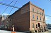 | May 23, 1997 (#97000481) | 107 Pendleton St. 36°50′02″N 81°30′57″W / 36.833889°N 81.515833°W / 36.833889; -81.515833 (R. T. Greer and Company) | Marion | |
| 8 | Henderson Building, Southwestern State Hospital |  | December 21, 1990 (#89001919) | E. Main St. 36°50′00″N 81°30′43″W / 36.833333°N 81.511944°W / 36.833333; -81.511944 (Henderson Building, Southwestern State Hospital) | Marion | Now part of Southwestern Virginia Mental Health Institute |
| 9 | Hotel Lincoln | 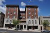 | July 21, 1995 (#95000897) | 107 E. Main St. 36°50′00″N 81°31′10″W / 36.833333°N 81.519444°W / 36.833333; -81.519444 (Hotel Lincoln) | Marion | |
| 10 | Hungry Mother State Park Historic District |  | April 12, 2007 (#07000303) | 2854 State Route 16 36°53′04″N 81°31′31″W / 36.884444°N 81.525278°W / 36.884444; -81.525278 (Hungry Mother State Park Historic District) | Marion | |
| 11 | Konnarock Training School | 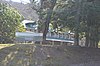 | June 5, 1997 (#97000483) | Junction of Whitetop and Konnarock Rds. 36°40′19″N 81°36′42″W / 36.671944°N 81.611528°W / 36.671944; -81.611528 (Konnarock Training School) | Konnarock | |
| 12 | Lincoln Theatre | 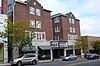 | December 17, 1992 (#92001710) | 117 E. Main St. 36°50′01″N 81°31′09″W / 36.833611°N 81.519167°W / 36.833611; -81.519167 (Lincoln Theatre) | Marion | |
| 13 | Marion Historic District |  | August 2, 2000 (#00000888) | Roughly along Main, Cherry, Strother, Lee, N. College, and College Sts.; also W. Cherry, E. Main, N. Main, Maple, N. Chestnut, Broad, and N. Commerce Sts. 36°49′59″N 81°31′13″W / 36.833056°N 81.520278°W / 36.833056; -81.520278 (Marion Historic District) | Marion | Second set of boundaries represents a boundary increase of July 28, 2011 |
| 14 | Marion Male Academy | 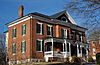 | November 2, 1989 (#89001915) | 343 College St. 36°49′53″N 81°31′34″W / 36.831250°N 81.526111°W / 36.831250; -81.526111 (Marion Male Academy) | Marion | |
| 15 | Norfolk & Western Railway Depot |  | February 8, 1995 (#95000025) | 651 N. Main St. 36°50′22″N 81°30′42″W / 36.839444°N 81.511667°W / 36.839444; -81.511667 (Norfolk & Western Railway Depot) | Marion | |
| 16 | Old Stone Tavern |  | July 8, 1982 (#82004595) | U.S. Route 11 36°51′52″N 81°26′12″W / 36.864583°N 81.436667°W / 36.864583; -81.436667 (Old Stone Tavern) | Atkins | |
| 17 | Preston House |  | November 25, 1969 (#69000280) | West of the junction of U.S. Route 11 and Chestnut Ridge Rd. 36°48′23″N 81°37′13″W / 36.806250°N 81.620278°W / 36.806250; -81.620278 (Preston House) | Marion | |
| 18 | Preston House |  | July 30, 1976 (#76002120) | Madison St. 36°52′16″N 81°45′41″W / 36.871111°N 81.761389°W / 36.871111; -81.761389 (Preston House) | Saltville | |
| 19 | Saltville Battlefields Historic District |  | March 25, 2010 (#10000096) | State Routes 91 and 107, and Cedar Branch Rd. 36°53′20″N 81°44′44″W / 36.888889°N 81.745556°W / 36.888889; -81.745556 (Saltville Battlefields Historic District) | Saltville | Extends into Washington County[7] |
| 20 | Saltville Historic District | 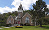 | April 12, 2002 (#02000367) | Main St., 1st Ave., Palmer Ave, Palmer Ln., Stadium Dr., and Henrytown Rd. 36°52′46″N 81°45′57″W / 36.879444°N 81.765833°W / 36.879444; -81.765833 (Saltville Historic District) | Saltville | |
| 21 | Scott-Walker House | 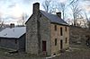 | May 19, 1994 (#94000450) | Eastern side of Buckeye Hollow Rd., 2 miles (3.2 km) southeast of Saltville 36°53′01″N 81°43′22″W / 36.883611°N 81.722778°W / 36.883611; -81.722778 (Scott-Walker House) | Saltville | |
| 22 | Smyth County Community Hospital |  | December 15, 2015 (#15000908) | 565 Radio Hill Rd. 36°51′05″N 81°30′28″W / 36.851378°N 81.507778°W / 36.851378; -81.507778 (Smyth County Community Hospital) | Marion | |
| 23 | Southwestern State Hospital Tubercular Building | Upload image | August 17, 2023 (#100009245) | 281 Bagley Cir. 36°50′03″N 81°30′36″W / 36.8341°N 81.5100°W / 36.8341; -81.5100 (Southwestern State Hospital Tubercular Building) | Marion | |
| 24 | Abijah Thomas House |  | November 28, 1980 (#80004225) | Southwest of Marion on Thomas Bridge Rd. 36°46′28″N 81°34′12″W / 36.774306°N 81.570000°W / 36.774306; -81.570000 (Abijah Thomas House) | Marion |
See also
Wikimedia Commons has media related to National Register of Historic Places in Smyth County, Virginia.
- List of National Historic Landmarks in Virginia
- National Register of Historic Places listings in Virginia
References
- ^ The latitude and longitude information provided in this table was derived originally from the National Register Information System, which has been found to be fairly accurate for about 99% of listings. Some locations in this table may have been corrected to current GPS standards.
- ^ National Park Service, United States Department of the Interior, "National Register of Historic Places: Weekly List Actions", retrieved May 24, 2024.
- ^ Numbers represent an alphabetical ordering by significant words. Various colorings, defined here, differentiate National Historic Landmarks and historic districts from other NRHP buildings, structures, sites or objects.
- ^ "National Register Information System". National Register of Historic Places. National Park Service. April 24, 2008.
- ^ The eight-digit number below each date is the number assigned to each location in the National Register Information System database, which can be viewed by clicking the number.
- ^ Loth, Calder, ed. The Virginia Landmarks Register. 4th ed. Charlottesville: UP of Virginia, 1999, 491.
- ^ "National Register of Historic Places Nomination Form: Saltville Battlefields Historic District" (PDF). Virginia Department of Historic Resources. Archived from the original (PDF) on January 15, 2010. Retrieved April 10, 2010.
- v
- t
- e
by county
- Accomack
- Albemarle
- Alleghany
- Amelia
- Amherst
- Appomattox
- Arlington
- Augusta
- Bath
- Bedford
- Bland
- Botetourt
- Brunswick
- Buchanan
- Buckingham
- Campbell
- Caroline
- Carroll
- Charles City
- Charlotte
- Chesterfield
- Clarke
- Craig
- Culpeper
- Cumberland
- Dickenson
- Dinwiddie
- Essex
- Fairfax
- Fauquier
- Floyd
- Fluvanna
- Franklin
- Frederick
- Giles
- Gloucester
- Goochland
- Grayson
- Greene
- Greensville
- Halifax
- Hanover
- Henrico
- Henry
- Highland
- Isle Of Wight
- James City
- King and Queen
- King George
- King William
- Lancaster
- Lee
- Loudoun
- Louisa
- Lunenburg
- Madison
- Mathews
- Mecklenburg
- Middlesex
- Montgomery
- Nelson
- New Kent
- Northampton
- Northumberland
- Nottoway
- Orange
- Page
- Patrick
- Pittsylvania
- Powhatan
- Prince Edward
- Prince George
- Prince William
- Pulaski
- Rappahannock
- Richmond
- Roanoke
- Rockbridge
- Rockingham
- Russell
- Scott
- Shenandoah
- Smyth
- Southampton
- Spotsylvania
- Stafford
- Surry
- Sussex
- Tazewell
- Warren
- Washington
- Westmoreland
- Wise
- Wythe
- York

by city
- Alexandria
- Bristol
- Buena Vista
- Charlottesville
- Chesapeake
- Colonial Heights
- Covington
- Danville
- Emporia
- Fairfax
- Falls Church
- Franklin
- Fredericksburg
- Galax
- Hampton
- Harrisonburg
- Hopewell
- Lexington
- Lynchburg
- Manassas
- Manassas Park
- Martinsville
- Newport News
- Norfolk
- Norton
- Petersburg
- Poquoson (no listings)
- Portsmouth
- Radford
- Richmond
- Roanoke
- Salem
- Staunton
- Suffolk
- Virginia Beach
- Waynesboro
- Williamsburg
- Winchester
Municipalities and communities of Smyth County, Virginia, United States | ||
|---|---|---|
County seat: Marion | ||
| Towns |  | |
| CDPs | ||
| Other communities | ||
| ||


