National Register of Historic Places listings in Prince George County, Virginia
This is a list of the National Register of Historic Places listings in Prince George County, Virginia.
This is intended to be a complete list of the properties and districts on the National Register of Historic Places in Prince George County, Virginia, United States. The locations of National Register properties and districts for which the latitude and longitude coordinates are included below, may be seen in a Google map.[1]
There are 10 properties and districts listed on the National Register in the county, including 1 National Historic Landmark.
This National Park Service list is complete through NPS recent listings posted May 31, 2024.[2]
Map all coordinates using OpenStreetMap
Download coordinates as:
- KML
- GPX (all coordinates)
- GPX (primary coordinates)
- GPX (secondary coordinates)
Current listings
| [3] | Name on the Register[4] | Image | Date listed[5] | Location | City or town | Description |
|---|---|---|---|---|---|---|
| 1 | Aberdeen |  | February 11, 2002 (#01001569) | 15301 State Route 10 37°13′37″N 77°08′17″W / 37.226806°N 77.137917°W / 37.226806; -77.137917 (Aberdeen) | Disputanta | |
| 2 | Brandon |  | November 12, 1969 (#69000271) | West bank of the James River at the end of Brandon Rd. 37°15′27″N 76°59′36″W / 37.257500°N 76.993333°W / 37.257500; -76.993333 (Brandon) | Burrowsville | |
| 3 | Chester Plantation |  | November 3, 2007 (#03000208) | 8401 Golf Course Dr. 37°08′20″N 77°15′18″W / 37.138889°N 77.255000°W / 37.138889; -77.255000 (Chester Plantation) | Disputanta | |
| 4 | Church of the Sacred Heart Parish | 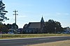 | February 8, 2012 (#12000020) | 9300 Community Ln. 37°11′15″N 77°19′28″W / 37.187500°N 77.324444°W / 37.187500; -77.324444 (Church of the Sacred Heart Parish) | Petersburg | |
| 5 | Evergreen |  | July 24, 1979 (#79003070) | East of Hopewell on Ruffin Rd. 37°17′27″N 77°14′26″W / 37.290833°N 77.240556°W / 37.290833; -77.240556 (Evergreen) | Hopewell | |
| 6 | Flowerdew Hundred Plantation | 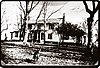 | August 1, 1975 (#75002030) | Flowerdew Hundred Rd., east of Hopewell[6] 37°17′34″N 77°06′22″W / 37.292778°N 77.106111°W / 37.292778; -77.106111 (Flowerdew Hundred Plantation) | Garysville | |
| 7 | Hatch Archeological Site (44PG51) | Upload image | November 6, 1989 (#89001923) | Address Restricted | Hopewell | |
| 8 | Martin's Brandon Church |  | October 31, 1980 (#80004213) | State Route 10 and Morning Star Rd. 37°12′53″N 77°04′31″W / 37.214722°N 77.075278°W / 37.214722; -77.075278 (Martin's Brandon Church) | Burrowsville | |
| 9 | Merchant's Hope Church |  | October 8, 1969 (#69000274) | West of the junction of State Route 10 and Merchants Hope Rd. 37°15′58″N 77°12′09″W / 37.266111°N 77.202500°W / 37.266111; -77.202500 (Merchant's Hope Church) | Hopewell | |
| 10 | Prince George County Courthouse Historic District |  | June 23, 2003 (#03000570) | 6400 Courthouse Rd. 37°13′15″N 77°17′16″W / 37.220833°N 77.287778°W / 37.220833; -77.287778 (Prince George County Courthouse Historic District) | Prince George |
See also
Wikimedia Commons has media related to National Register of Historic Places in Prince George County, Virginia.
- List of National Historic Landmarks in Virginia
- National Register of Historic Places listings in Virginia
- National Register of Historic Places listings in Hopewell, Virginia
References
- ^ The latitude and longitude information provided in this table was derived originally from the National Register Information System, which has been found to be fairly accurate for about 99% of listings. Some locations in this table may have been corrected to current GPS standards.
- ^ National Park Service, United States Department of the Interior, "National Register of Historic Places: Weekly List Actions", retrieved May 31, 2024.
- ^ Numbers represent an alphabetical ordering by significant words. Various colorings, defined here, differentiate National Historic Landmarks and historic districts from other NRHP buildings, structures, sites or objects.
- ^ "National Register Information System". National Register of Historic Places. National Park Service. April 24, 2008.
- ^ The eight-digit number below each date is the number assigned to each location in the National Register Information System database, which can be viewed by clicking the number.
- ^ DeLorme. Virginia Atlas & Gazetteer. 7th ed. Yarmouth: DeLorme, 2009, 49.
- v
- t
- e
by county
- Accomack
- Albemarle
- Alleghany
- Amelia
- Amherst
- Appomattox
- Arlington
- Augusta
- Bath
- Bedford
- Bland
- Botetourt
- Brunswick
- Buchanan
- Buckingham
- Campbell
- Caroline
- Carroll
- Charles City
- Charlotte
- Chesterfield
- Clarke
- Craig
- Culpeper
- Cumberland
- Dickenson
- Dinwiddie
- Essex
- Fairfax
- Fauquier
- Floyd
- Fluvanna
- Franklin
- Frederick
- Giles
- Gloucester
- Goochland
- Grayson
- Greene
- Greensville
- Halifax
- Hanover
- Henrico
- Henry
- Highland
- Isle Of Wight
- James City
- King and Queen
- King George
- King William
- Lancaster
- Lee
- Loudoun
- Louisa
- Lunenburg
- Madison
- Mathews
- Mecklenburg
- Middlesex
- Montgomery
- Nelson
- New Kent
- Northampton
- Northumberland
- Nottoway
- Orange
- Page
- Patrick
- Pittsylvania
- Powhatan
- Prince Edward
- Prince George
- Prince William
- Pulaski
- Rappahannock
- Richmond
- Roanoke
- Rockbridge
- Rockingham
- Russell
- Scott
- Shenandoah
- Smyth
- Southampton
- Spotsylvania
- Stafford
- Surry
- Sussex
- Tazewell
- Warren
- Washington
- Westmoreland
- Wise
- Wythe
- York

by city
- Alexandria
- Bristol
- Buena Vista
- Charlottesville
- Chesapeake
- Colonial Heights
- Covington
- Danville
- Emporia
- Fairfax
- Falls Church
- Franklin
- Fredericksburg
- Galax
- Hampton
- Harrisonburg
- Hopewell
- Lexington
- Lynchburg
- Manassas
- Manassas Park
- Martinsville
- Newport News
- Norfolk
- Norton
- Petersburg
- Poquoson (no listings)
- Portsmouth
- Radford
- Richmond
- Roanoke
- Salem
- Staunton
- Suffolk
- Virginia Beach
- Waynesboro
- Williamsburg
- Winchester
Municipalities and communities of Prince George County, Virginia, United States | ||
|---|---|---|
County seat: Prince George | ||
| CDPs |  | |
| Other communities | ||
| ||


