National Register of Historic Places listings in Sheridan County, Nebraska

This is a list of the National Register of Historic Places listings in Sheridan County, Nebraska.
This is intended to be a complete list of the properties and districts on the National Register of Historic Places in Sheridan County, Nebraska, United States. The locations of National Register properties and districts for which the latitude and longitude coordinates are included below, may be seen in a map.[1]
There are 10 properties and districts listed on the National Register in the county.
This National Park Service list is complete through NPS recent listings posted June 7, 2024.[2]
Map all coordinates using OpenStreetMap
Download coordinates as:
- KML
- GPX (all coordinates)
- GPX (primary coordinates)
- GPX (secondary coordinates)
Current listings
| [3] | Name on the Register | Image | Date listed[4] | Location | City or town | Description |
|---|---|---|---|---|---|---|
| 1 | Antioch Potash Plants | 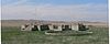 | May 16, 1979 (#79001455) | Nebraska Highway 2 at Antioch 42°04′12″N 102°35′36″W / 42.070000°N 102.593333°W / 42.070000; -102.593333 (Antioch Potash Plants) | Antioch | |
| 2 | Camp Sheridan and Spotted Tail Indian Agency |  | November 19, 1974 (#74001140) | Address Restricted 42°51′07″N 102°44′39″W / 42.85198°N 102.74421°W / 42.85198; -102.74421 (Camp Sheridan and Spotted Tail Indian Agency) | Hay Springs | |
| 3 | Colclesser Bridge | Upload image | June 29, 1992 (#92000729) | County road over the Niobrara River, 11 miles (18 km) south of Rushville 42°37′18″N 102°18′48″W / 42.621722°N 102.313337°W / 42.621722; -102.313337 (Colclesser Bridge) | Rushville | |
| 4 | District No. 119 North School |  | August 30, 2010 (#10000606) | South side of Sandy Ave. 42°03′29″N 102°16′38″W / 42.058057°N 102.277159°W / 42.058057; -102.277159 (District No. 119 North School) | Ellsworth | School Buildings in Nebraska MPS |
| 5 | Lee and Gottliebe Fritz House |  | November 28, 2003 (#03001213) | 132 North Oak 42°48′16″N 102°12′18″W / 42.80445°N 102.20498°W / 42.80445; -102.20498 (Lee and Gottliebe Fritz House) | Gordon | |
| 6 | Gourley's Opera House |  | July 6, 1988 (#88000943) | 2nd St. 42°43′06″N 102°27′41″W / 42.718333°N 102.461389°W / 42.718333; -102.461389 (Gourley's Opera House) | Rushville | Now the Plains Theater.[5] |
| 7 | Loosveldt Bridge | Upload image | June 29, 1992 (#92000730) | Private ranch road over the Niobrara River, 9.1 miles (14.6 km) southeast of Rushville 42°34′53″N 102°23′02″W / 42.581389°N 102.383889°W / 42.581389; -102.383889 (Loosveldt Bridge) | Rushville | |
| 8 | Sheridan County Courthouse |  | January 10, 1990 (#89002216) | 2nd and Sprague Sts. 42°43′04″N 102°27′36″W / 42.717778°N 102.46°W / 42.717778; -102.46 (Sheridan County Courthouse) | Rushville | |
| 9 | Spade Ranch |  | February 28, 1980 (#80002464) | 23 miles (37 km) northeast of Ellsworth 42°18′23″N 102°04′47″W / 42.306389°N 102.079722°W / 42.306389; -102.079722 (Spade Ranch) | Ellsworth | |
| 10 | Spade Ranch Store |  | September 3, 2010 (#10000629) | West side of Nebraska Highway 27/Lot 5 of Ellsworth 42°03′34″N 102°16′52″W / 42.059444°N 102.281111°W / 42.059444; -102.281111 (Spade Ranch Store) | Ellsworth |
See also
Wikimedia Commons has media related to National Register of Historic Places in Sheridan County, Nebraska.
- List of National Historic Landmarks in Nebraska
- National Register of Historic Places listings in Nebraska
References
- ^ The latitude and longitude information provided in this table was derived originally from the National Register Information System, which has been found to be fairly accurate for about 99% of listings. Some locations in this table may have been corrected to current GPS standards.
- ^ National Park Service, United States Department of the Interior, "National Register of Historic Places: Weekly List Actions", retrieved June 7, 2024.
- ^ Numbers represent an alphabetical ordering by significant words. Various colorings, defined here, differentiate National Historic Landmarks and historic districts from other NRHP buildings, structures, sites or objects.
- ^ The eight-digit number below each date is the number assigned to each location in the National Register Information System database, which can be viewed by clicking the number.
- ^ "Nebraska National Register Sites in Sheridan County".[usurped] Nebraska State Historical Society.[usurped] Retrieved 2011-04-23.
- v
- t
- e
- Sheridan County Courthouse
- Spade Ranch‡

- Antioch Potash Plants
- Camp Sheridan and Spotted Tail Indian Agency
- Colclesser Bridge
- District No. 119 North School
- Gourley's Opera House
- Lee and Gottliebe Fritz House
- Loosveldt Bridge
- Spade Ranch Store
‡This historic property also has portions in an adjacent county.
See also: National Register of Historic Places listings in Sheridan County, Nebraska and List of National Historic Landmarks in Nebraska
| ||
|---|---|---|
| Topics |  | |
| Lists by county |
| |
| Other lists |
| |
| ||


Municipalities and communities of Sheridan County, Nebraska, United States | ||
|---|---|---|
County seat: Rushville | ||
| Cities |  | |
| Villages | ||
| CDP | ||
| Unincorporated communities | ||
| Ghost town | ||
| Indian reservation | ||
| Footnotes | ‡This populated place also has portions in an adjacent county or counties | |
| ||


