National Register of Historic Places listings in Cass County, Nebraska

This is a list of the National Register of Historic Places listings in Cass County, Nebraska.
This is intended to be a complete list of the properties and districts on the National Register of Historic Places in Cass County, Nebraska, United States. The locations of National Register properties and districts for which the latitude and longitude coordinates are included below, may be seen in a map.[1]
There are 32 properties and districts listed on the National Register in the county, including 1 National Historic Landmark.
This National Park Service list is complete through NPS recent listings posted May 10, 2024.[2]
Map all coordinates using OpenStreetMap
Download coordinates as:
- KML
- GPX (all coordinates)
- GPX (primary coordinates)
- GPX (secondary coordinates)
Current listings
| [3] | Name on the Register[4] | Image | Date listed[5] | Location | City or town | Description |
|---|---|---|---|---|---|---|
| 1 | Agricultural Society Building (Auditorium) |  | March 3, 2023 (#100008673) | 101 West Eldora Ave. 40°52′12″N 96°08′25″W / 40.8699°N 96.1404°W / 40.8699; -96.1404 (Agricultural Society Building (Auditorium)) | Weeping Water | |
| 2 | Ashland Archeological Site | Upload image | February 10, 1975 (#75001090) | Both sides of a small stream that meets Salt Creek immediately above its confluence with the Platte River[6] 41°01′54″N 96°18′59″W / 41.031722°N 96.316389°W / 41.031722; -96.316389 (Ashland Archeological Site) | Ashland | |
| 3 | Bridge |  | June 29, 1992 (#92000707) | County road over an unnamed stream, 4.7 miles (7.6 km) southeast of Louisville 40°58′22″N 96°04′55″W / 40.972778°N 96.081944°W / 40.972778; -96.081944 (Bridge) | Louisville | part of the Highway Bridges in Nebraska Multiple Property Submission (MPS) |
| 4 | Cass County Courthouse |  | January 10, 1990 (#89002248) | Main St. between 3rd and 4th Sts. 41°00′42″N 95°53′01″W / 41.011667°N 95.8835°W / 41.011667; -95.8835 (Cass County Courthouse) | Plattsmouth | part of the County Courthouses of Nebraska MPS |
| 5 | Theodore Davis Site | Upload image | May 19, 1972 (#72000743) | Address Restricted | Weeping Water | |
| 6 | George E. Dovey House |  | November 5, 2018 (#100003091) | 423 N 4th St. 41°00′54″N 95°53′02″W / 41.0151°N 95.8838°W / 41.0151; -95.8838 (George E. Dovey House) | Plattsmouth | |
| 7 | The Elms |  | March 24, 1977 (#77000824) | 204 East F Street[7] 40°50′39″N 96°17′31″W / 40.844206°N 96.291825°W / 40.844206; -96.291825 (The Elms) | Elmwood | Home of author Bess Streeter Aldrich.[8] |
| 8 | Paul Fitzgerald House | 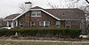 | March 2, 2006 (#06000100) | 513 E. 2nd St. 41°00′05″N 96°09′23″W / 41.00125°N 96.1565°W / 41.00125; -96.1565 (Paul Fitzgerald House) | Louisville | |
| 9 | Paul Gering House |  | July 12, 2006 (#06000604) | 423 N. 6th St. 41°00′54″N 95°53′09″W / 41.01506°N 95.88586°W / 41.01506; -95.88586 (Paul Gering House) | Plattsmouth | |
| 10 | Gibson House | 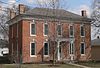 | March 20, 1986 (#86000471) | 107 Clinton 40°52′15″N 96°08′41″W / 40.87072°N 96.14475°W / 40.87072; -96.14475 (Gibson House) | Weeping Water | |
| 11 | Walker Gilmore site (22CC28) | Upload image | October 15, 1966 (#66000441) | Northeastern quarter of the northeastern quarter of Section 28, Township 11 North, Range 14 East[9] 40°53′59″N 95°50′14″W / 40.899722°N 95.837222°W / 40.899722; -95.837222 (Walker Gilmore site (22CC28)) | Murray | |
| 12 | James and Margaret Greer Farmstead |  | March 21, 2011 (#11000103) | 6315 202nd St.[10] 40°53′18″N 96°26′49″W / 40.888333°N 96.446944°W / 40.888333; -96.446944 (James and Margaret Greer Farmstead) | Alvo | |
| 13 | Kehlbeck Farmstead | 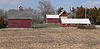 | September 26, 1985 (#85002577) | Address Restricted | Avoca | |
| 14 | Christian Kupke Farmstead |  | December 19, 2012 (#12001073) | 32618 Church Rd. 40°57′27″N 96°14′54″W / 40.957507°N 96.248392°W / 40.957507; -96.248392 (Christian Kupke Farmstead) | Murdock | Operated under name "The Farm at Long Lane, LLC"[11] |
| 15 | Velosco V. Leonard House |  | November 5, 2018 (#100003092) | 323 N 6th St. 41°00′51″N 95°53′10″W / 41.0142°N 95.8862°W / 41.0142; -95.8862 (Velosco V. Leonard House) | Plattsmouth | |
| 16 | Manley School |  | December 30, 2004 (#04001414) | 115 Cherry St. 40°55′14″N 96°10′04″W / 40.9205°N 96.16772°W / 40.9205; -96.16772 (Manley School) | Manley | part of the School Buildings in Nebraska MPS |
| 17 | McLaughlin-Waugh-Dovey House |  | October 14, 1980 (#80002443) | 414 B Ave. 41°00′49″N 95°53′05″W / 41.01353°N 95.88464°W / 41.01353; -95.88464 (McLaughlin-Waugh-Dovey House) | Plattsmouth | |
| 18 | Morgan-Fricke House |  | July 27, 2021 (#100006790) | 623 North 6th St. 41°01′02″N 95°53′10″W / 41.0172°N 95.8861°W / 41.0172; -95.8861 (Morgan-Fricke House) | Plattsmouth | |
| 19 | Naomi Institute |  | March 24, 1977 (#77000825) | 3 miles (4.8 km) east of Murray 40°55′46″N 95°51′10″W / 40.92933°N 95.85289°W / 40.92933; -95.85289 (Naomi Institute) | Murray | |
| 20 | Nehawka Flint Quarries | Upload image | January 26, 1970 (#70000368) | Address Restricted | Nehawka | |
| 21 | Nehawka Public Library |  | December 5, 2002 (#02001481) | Southeast corner of Elm and Maple Streets.[12] 40°49′45″N 95°59′19″W / 40.82906°N 95.98853°W / 40.82906; -95.98853 (Nehawka Public Library) | Nehawka | |
| 22 | Capt. John O'Rourke House |  | March 2, 2006 (#06000102) | 424 N. 6th St. 41°00′54″N 95°53′11″W / 41.01508°N 95.8865°W / 41.01508; -95.8865 (Capt. John O'Rourke House) | Plattsmouth | |
| 23 | Glenn and Addie Perry Farmhouse |  | November 8, 2006 (#06000999) | Address Restricted | Plattsmouth | |
| 24 | Gottfried Gustav Pitz Barn |  | August 27, 2012 (#12000564) | 903 Livingston Rd. 41°00′07″N 95°52′30″W / 41.00203°N 95.87509°W / 41.00203; -95.87509 (Gottfried Gustav Pitz Barn) | Plattsmouth | |
| 25 | Plattsmouth Bridge |  | April 15, 1993 (#92000755) | U.S. Route 34 over the Missouri River 41°00′03″N 95°52′01″W / 41.00096°N 95.866836°W / 41.00096; -95.866836 (Plattsmouth Bridge) | Plattsmouth | Extends into Mills County, Iowa; part of the Highway Bridges in Nebraska MPS |
| 26 | Plattsmouth High School | 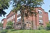 | March 13, 2020 (#100005052) | 814 Main St. 41°00′41″N 95°53′24″W / 41.0113°N 95.8899°W / 41.0113; -95.8899 (Plattsmouth High School) | Plattsmouth | Now the First Baptist School |
| 27 | Plattsmouth Main Street Historic District |  | September 26, 1985 (#85002585) | Main St. bounded by Avenue A, S. and N. 3rd St., 1st Ave. and S. and N. 7th St. 41°00′41″N 95°53′04″W / 41.011389°N 95.884444°W / 41.011389; -95.884444 (Plattsmouth Main Street Historic District) | Plattsmouth | |
| 28 | Peter E. Ruffner House |  | March 22, 2016 (#16000105) | 501 N. 8th St. 41°00′56″N 95°53′18″W / 41.015585°N 95.888388°W / 41.015585; -95.888388 (Peter E. Ruffner House) | Plattsmouth | |
| 29 | Snoke Farmstead |  | March 5, 1998 (#98000189) | 23416 O St., U.S. Highway 34 40°48′50″N 96°23′42″W / 40.813815°N 96.394876°W / 40.813815; -96.394876 (Snoke Farmstead) | Eagle | Farmstead from 1875. |
| 30 | Union Jail |  | July 12, 2006 (#06000605) | 1st and Rock St. 40°48′44″N 95°55′23″W / 40.81236°N 95.92306°W / 40.81236; -95.92306 (Union Jail) | Union | |
| 31 | Weeping Water Historic District |  | December 8, 1972 (#72000744) | Randolph and H Sts. 40°52′16″N 96°08′32″W / 40.871111°N 96.142222°W / 40.871111; -96.142222 (Weeping Water Historic District) | Weeping Water | Consists of the 1870 Congregational Church, the Heritage House Museum, and the Jesse C. Fate Office.[13] |
| 32 | Young Cemetery Cabin |  | December 30, 2004 (#04001408) | Young Ln. E400 40°56′26″N 95°54′17″W / 40.94058°N 95.90469°W / 40.94058; -95.90469 (Young Cemetery Cabin) | Plattsmouth |
See also
- List of National Historic Landmarks in Nebraska
- National Register of Historic Places listings in Nebraska
References
- ^ The latitude and longitude information provided in this table was derived originally from the National Register Information System, which has been found to be fairly accurate for about 99% of listings. Some locations in this table may have been corrected to current GPS standards.
- ^ National Park Service, United States Department of the Interior, "National Register of Historic Places: Weekly List Actions", retrieved May 10, 2024.
- ^ Numbers represent an alphabetical ordering by significant words. Various colorings, defined here, differentiate National Historic Landmarks and historic districts from other NRHP buildings, structures, sites or objects.
- ^ "National Register Information System". National Register of Historic Places. National Park Service. April 24, 2008.
- ^ The eight-digit number below each date is the number assigned to each location in the National Register Information System database, which can be viewed by clicking the number.
- ^ Hill, A.T., and Paul Cooper. "The Champe Site: Excavation of a Prehistoric House in Douglas County, Nebraska." Nebraska History Magazine 18.4 (1937): 249-278: 249.
- ^ "House Tours". Bess Streeter Aldrich Foundation Web Site. Retrieved 2013-07-27.
- ^ Jeffries, Janet. "National Register of Historic Places Inventory-Nomination Form: 'The Elms'".[usurped] Nebraska State Historical Society.[usurped] Retrieved 2013-07-27.
- ^ Sterns, Fred H. "A Stratification of Cultures in Eastern Nebraska". American Anthropologist 17.1 (1915): 121-127: 122.
- ^ See photo.
- ^ "National Register of Historic Places". The Farm at Long Lane, LLC. Retrieved 2013-07-28.
- ^ See photo.
- ^ Kolberg, Persijs. "National Register of Historic Places Inventory—Nomination Form".[usurped] Nebraska State Historical Society.[usurped] Retrieved 2012-04-19.
External links
Wikimedia Commons has media related to National Register of Historic Places in Cass County, Nebraska.
- Nebraska National Register Sites in Cass County[usurped]–Nebraska State Historical Society
- v
- t
- e

- Adams
- Antelope
- Arthur
- Banner
- Blaine
- Boone
- Box Butte
- Boyd
- Brown
- Buffalo
- Burt
- Butler
- Cass
- Cedar
- Chase
- Cherry
- Cheyenne
- Clay
- Colfax
- Cuming
- Custer
- Dakota
- Dawes
- Dawson
- Deuel
- Dixon
- Dodge
- Douglas
- Dundy
- Fillmore
- Franklin
- Frontier
- Furnas
- Gage
- Garden
- Garfield
- Gosper
- Grant
- Greeley
- Hall
- Hamilton
- Harlan
- Hayes
- Hitchcock
- Holt
- Hooker
- Howard
- Jefferson
- Johnson
- Kearney
- Keith
- Keya Paha
- Kimball
- Knox
- Lancaster
- Lincoln
- Logan
- Loup
- Madison
- McPherson
- Merrick
- Morrill
- Nance
- Nemaha
- Nuckolls
- Otoe
- Pawnee
- Perkins
- Phelps
- Pierce
- Platte
- Polk
- Red Willow
- Richardson
- Rock
- Saline
- Sarpy
- Saunders
- Scotts Bluff
- Seward
- Sheridan
- Sherman
- Sioux
- Stanton
- Thayer
- Thomas
- Thurston
- Valley
- Washington
- Wayne
- Webster
- Wheeler
- York
- Bridges
- Historic districts
- Houses
- National Historic Landmarks
- Properties of religious function
- Railway stations
 Category
 List
List National Register of Historic Places Portal


Municipalities and communities of Cass County, Nebraska, United States | ||
|---|---|---|
County seat: Plattsmouth | ||
| Cities |  | |
| Villages | ||
| CDPs |
| |
| Unincorporated communities | ||
| Ghost towns | ||
| ||


