Danh sách quận của Wisconsin

Danh sách này liệt kê 72 quận của tiểu bang Wisconsin, Hoa Kỳ. Tiểu bang Wisconsin được thành lập từ vùng lãnh thổ Wisconsin ngày 29 tháng 5 năm 1848, với 28 quận.
Danh sách các quận
| Quận | Mã FIPS [1] | Quận lỵ [2] | Thành lập [2] | Thành lập từ [3] | Từ nguyên [3] | Dân số [2][4] | Diện tích [2][4] | Bản đồ
|
|---|---|---|---|---|---|---|---|---|
| Adams County | 001 | Friendship | 1848 | Quận Portage | John Quincy Adams (1767-1848), President of the United States 1825-1829 | &000000000002087500000020.875 | &0000000000000648000000648 sq mi (&00000000000016780000001.678 km2) | 
|
| Ashland County | 003 | Ashland | 1860 | unorganized territory | Ashland, Henry Clay's estate in Kentucky | &000000000001615700000016.157 | &00000000000010440000001.044 sq mi (&00000000000027040000002.704 km2) | 
|
| Barron County | 005 | Barron | 1859 | Dallas and Polk Counties | Henry D. Barron, state senator and circuit court judge. | &000000000004587000000045.870 | &0000000000000863000000863 sq mi (&00000000000022350000002.235 km2) | 
|
| Bayfield County | 007 | Washburn | 1845 | Quận Ashland | Henry Bayfield, Royal naval officer and first to survey the Great Lakes area | &000000000001501400000015.014 | &00000000000014760000001.476 sq mi (&00000000000038230000003.823 km2) | 
|
| Brown County | 009 | Green Bay | 1818 | unorganized territory | Major General Jacob Brown (1775-1828), a commanding general of the United States Army during the War of 1812 | &0000000000248007000000248.007 | &0000000000000529000000529 sq mi (&00000000000013700000001.370 km2) | 
|
| Buffalo County | 011 | Alma | 1853 | Quận Trempealeau | The Buffalo River, which flows through the county. | &000000000001358700000013.587 | &0000000000000684000000684 sq mi (&00000000000017720000001.772 km2) | 
|
| Burnett County | 013 | Siren | 1856 | Quận Polk | Thomas P. Burnett, state legislator | &000000000001545700000015.457 | &0000000000000822000000822 sq mi (&00000000000021290000002.129 km2) | 
|
| Calumet County | 015 | Chilton | 1836 | unorganized territory | The French word for a Menominee peace pipe. | &000000000004897100000048.971 | &0000000000000320000000320 sq mi (&0000000000000829000000829 km2) | 
|
| Chippewa County | 017 | Chippewa Falls | 1845 | Quận Crawford | The Ojibwe nation of Native Americans (historically referred to as Chippewa) | &000000000006241500000062.415 | &00000000000010100000001.010 sq mi (&00000000000026160000002.616 km2) | 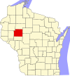
|
| Clark County | 019 | Neillsville | 1853 | Quận Crawford | George Rogers Clark (1752-1812), Revolutionary War general | &000000000003469000000034.690 | &00000000000012160000001.216 sq mi (&00000000000031490000003.149 km2) | 
|
| Columbia County | 021 | Portage | 1846 | Quận Portage | Christopher Columbus (1451-1506), navigator and explorer | &000000000005683300000056.833 | &0000000000000774000000774 sq mi (&00000000000020050000002.005 km2) | 
|
| Crawford County | 023 | Prairie du Chien | 1818 | unorganized territory | William Harris Crawford (1772-1834), United States Senator from Georgia 1807-1813 and Secretary of the Treasury 1816-1825 | &000000000001664400000016.644 | &0000000000000573000000573 sq mi (&00000000000014840000001.484 km2) | 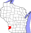
|
| Dane County | 025 | Madison | 1836 | unorganized territory | Nathan Dane (1752-1835), delegate to the First Continental Congress 1785-1788 | &0000000000488073000000488.073 | &00000000000012020000001.202 sq mi (&00000000000031130000003.113 km2) | 
|
| Dodge County | 027 | Juneau | 1836 | unorganized territory | Henry Dodge (1782-1867), Territorial Governor of Wisconsin 1848-1857 | &000000000008875900000088.759 | &0000000000000882000000882 sq mi (&00000000000022840000002.284 km2) | 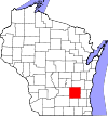
|
| Door County | 029 | Sturgeon Bay | 1851 | Brown County | A dangerous water passage near Door Peninsula known as porte des morts, or "door of the dead" in Tiếng Pháp | &000000000002778500000027.785 | &0000000000000483000000483 sq mi (&00000000000012510000001.251 km2) | 
|
| Douglas County | 031 | Superior | 1854 | unorganized territory | Stephen Douglas (1813-1861), United States Senator 1847-1861 | &000000000004415900000044.159 | &00000000000013090000001.309 sq mi (&00000000000033900000003.390 km2) | 
|
| Dunn County | 033 | Menomonie | 1854 | Chippewa County | Charles Dunn, state senator và chief justice of Wisconsin Territory | &000000000004385700000043.857 | &0000000000000852000000852 sq mi (&00000000000022070000002.207 km2) | 
|
| Eau Claire County | 035 | Eau Claire | 1856 | Chippewa County | City of Eau Claire, itself French for "clear water" | &000000000009873600000098.736 | &0000000000000638000000638 sq mi (&00000000000016520000001.652 km2) | 
|
| Florence County | 037 | Florence (CDP) | 1882 | Marinette and Oconto Counties | Florence Julst, the first white woman to settle in the area | &00000000000044230000004.423 | &0000000000000488000000488 sq mi (&00000000000012640000001.264 km2) | 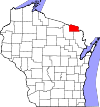
|
| Fond du Lac County | 039 | Fond du Lac | 1836 | unorganized territory | French for "foot of the lake" | &0000000000101633000000101.633 | &0000000000000723000000723 sq mi (&00000000000018730000001.873 km2) | 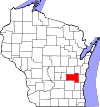
|
| Forest County | 041 | Crandon | 1885 | Langlade and Oconto Counties | Forest which covered the area when it was settled | &00000000000093040000009.304 | &00000000000010140000001.014 sq mi (&00000000000026260000002.626 km2) | 
|
| Grant County | 043 | Lancaster | 1836 | unorganized territory | Probably a trader named Grant, who made contact with area natives in 1810, but about whom little else is known | &000000000005120800000051.208 | &00000000000011480000001.148 sq mi (&00000000000029730000002.973 km2) | 
|
| Green County | 045 | Monroe | 1836 | unorganized territory | Nathanael Greene (1742-1786), quartermaster general during the American Revolutionary War | &000000000003684200000036.842 | &0000000000000584000000584 sq mi (&00000000000015130000001.513 km2) | 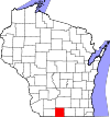
|
| Green Lake County | 047 | Green Lake | 1858 | Marquette District | Green Lake, located within the county | &000000000001905100000019.051 | &0000000000000354000000354 sq mi (&0000000000000917000000917 km2) | 
|
| Iowa County | 049 | Dodgeville | 1829 | unorganized territory | Iowa tribe of Native Americans | &000000000002368700000023.687 | &0000000000000763000000763 sq mi (&00000000000019760000001.976 km2) | 
|
| Iron County | 051 | Hurley | 1893 | Ashland and Oneida Counties | Local iron deposits | &00000000000059160000005.916 | &0000000000000757000000757 sq mi (&00000000000019610000001.961 km2) | 
|
| Jackson County | 053 | Black River Falls | 1853 | La Crosse County | Andrew Jackson (1767-1845), President of the United States 1829–1837 | &000000000002044900000020.449 | &0000000000000987000000987 sq mi (&00000000000025560000002.556 km2) | 
|
| Jefferson County | 055 | Jefferson | 1836 | Milwaukee County | Thomas Jefferson (1743-1826), President of the United States (1801-1809) | &000000000008368600000083.686 | &0000000000000557000000557 sq mi (&00000000000014430000001.443 km2) | 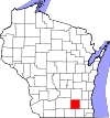
|
| Juneau County | 057 | Mauston | 1856 | Quận Adams | Solomon Juneau (1793-1856), founder of what would become Milwaukee | &000000000002666400000026.664 | &0000000000000768000000768 sq mi (&00000000000019890000001.989 km2) | 
|
| Kenosha County | 059 | Kenosha | 1850 | Quận Racine | A Native American word meaning "place of the pike" | &0000000000166426000000166.426 | &0000000000000273000000273 sq mi (&0000000000000707000000707 km2) | 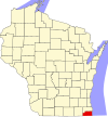
|
| Kewaunee County | 061 | Kewaunee | 1852 | Quận Manitowoc | Either a Potawatomi word meaning "river of the lost" or an Ojibwe word meaning "prairie hen", "wild duck" or "to go around" | &000000000002057400000020.574 | &0000000000000343000000343 sq mi (&0000000000000888000000888 km2) | 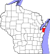
|
| La Crosse County | 063 | La Crosse | 1851 | unorganized territory | The Native American game of lacrosse | &0000000000114638000000114.638 | &0000000000000453000000453 sq mi (&00000000000011730000001.173 km2) | 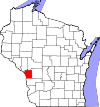
|
| Lafayette County | 065 | Darlington | 1846 | Quận Iowa | Gilbert du Motier, marquis de La Fayette (1757-1834), a French general in the American Revolutionary War | &000000000001683600000016.836 | &0000000000000634000000634 sq mi (&00000000000016420000001.642 km2) | 
|
| Langlade County | 067 | Antigo | 1879 | unorganized territory | Charles de Langlade (1729 – c.1800), American Revolutionary War veteran and United States Indian Agent in Green Bay | &000000000001997700000019.977 | &0000000000000873000000873 sq mi (&00000000000022610000002.261 km2) | 
|
| Lincoln County | 069 | Merrill | 1874 | Marathon County | Abraham Lincoln (1809-1865), President of the United States 1861-1865 | &000000000002874300000028.743 | &0000000000000883000000883 sq mi (&00000000000022870000002.287 km2) | 
|
| Manitowoc County | 071 | Manitowoc | 1836 | unorganized territory | Munedoo-owk, a Ojibwe word meaning "the place of the good spirit" | &000000000008144200000081.442 | &0000000000000592000000592 sq mi (&00000000000015330000001.533 km2) | 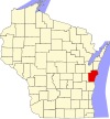
|
| Marathon County | 073 | Wausau | 1850 | Portage County | Marathon, Greece | &0000000000134063000000134.063 | &00000000000015450000001.545 sq mi (&00000000000040020000004.002 km2) | 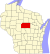
|
| Marinette County | 075 | Marinette | 1879 | Oconto County | Marie Antoinette Chevalier, Native American wife of early an fur trapper | &000000000004174900000041.749 | &00000000000014020000001.402 sq mi (&00000000000036310000003.631 km2) | 
|
| Marquette County | 077 | Montello | 1836 | Marquette District | Father Pere Jacques Marquette, missionary and explorer | &000000000001540400000015.404 | &0000000000000456000000456 sq mi (&00000000000011810000001.181 km2) | 
|
| Menominee County | 078 | Keshena | 1961 | Menominee Indian Reservation,Shawano, and Oconto Counties | Menominee nation of Native Americans | &00000000000042320000004.232 | &0000000000000358000000358 sq mi (&0000000000000927000000927 km2) | 
|
| Milwaukee County | 079 | Milwaukee | 1835 | unorganized territory | Mahnawaukee-Seepe, a Native American word meaning "gathering place by the river" | &0000000000947735000000947.735 | &0000000000000242000000242 sq mi (&0000000000000627000000627 km2) | 
|
| Monroe County | 081 | Sparta | 1854 | La Crosse County | James Monroe (1758-1831), President of the United States 1817-1825 | &000000000004467300000044.673 | &0000000000000901000000901 sq mi (&00000000000023340000002.334 km2) | 
|
| Oconto County | 083 | Oconto | 1851 | unorganized territory | A Native American settlement and the Oconto River, whose name means "plentiful with fish" | &000000000003766000000037.660 | &0000000000000998000000998 sq mi (&00000000000025850000002.585 km2) | 
|
| Oneida County | 085 | Rhinelander | 1885 | Lincoln County | Oneida nation of Native Americans | &000000000003599800000035.998 | &00000000000011250000001.125 sq mi (&00000000000029140000002.914 km2) | 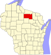
|
| Outagamie County | 087 | Appleton | 1851 | Brown County | Outagamie nation of Native Americans | &0000000000176695000000176.695 | &0000000000000640000000640 sq mi (&00000000000016580000001.658 km2) | 
|
| Ozaukee County | 089 | Port Washington | 1853 | Milwaukee County | The Ojibwe word for the Sauk nation | &000000000008639500000086.395 | &0000000000000232000000232 sq mi (&0000000000000601000000601 km2) | 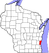
|
| Pepin County | 091 | Durand | 1858 | Dunn County | Pierre and Jean Pepin du Chardonnets, explorers | &00000000000074690000007.469 | &0000000000000232000000232 sq mi (&0000000000000601000000601 km2) | 
|
| Pierce County | 093 | Ellsworth | 1853 | Saint Croix County | Franklin Pierce (1804-1869), President of the United States 1853-1857 | &000000000004101900000041.019 | &0000000000000576000000576 sq mi (&00000000000014920000001.492 km2) | 
|
| Polk County | 095 | Balsam Lake | 1853 | Saint Croix County | James Polk (1795-1849), President of the United States (1845-1849) | &000000000004420500000044.205 | &0000000000000917000000917 sq mi (&00000000000023750000002.375 km2) | 
|
| Portage County | 097 | Stevens Point | 1836 | unorganized territory | Passage between the Fox and Wisconsin Rivers | &000000000007001900000070.019 | &0000000000000806000000806 sq mi (&00000000000020880000002.088 km2) | 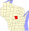
|
| Price County | 099 | Phillips | 1879 | Chippewa and Lincoln Counties | William T. Price, president of the Wisconsin Senate | &000000000001415900000014.159 | &00000000000012530000001.253 sq mi (&00000000000032450000003.245 km2) | 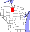
|
| Racine County | 101 | Racine | 1836 | unorganized territory | Racine, the French word for "root", after the Root River, which flows through the county | &0000000000195408000000195.408 | &0000000000000333000000333 sq mi (&0000000000000862000000862 km2) | 
|
| Richland County | 103 | Richland Center | 1842 | Iowa County | The rich soil of the area | &000000000001802100000018.021 | &0000000000000586000000586 sq mi (&00000000000015180000001.518 km2) | 
|
| Rock County | 105 | Janesville | 1836 | unorganized territory | Rock River, which flows through the county | &0000000000160331000000160.331 | &0000000000000720000000720 sq mi (&00000000000018650000001.865 km2) | 
|
| Rusk County | 107 | Ladysmith | 1901 | Chippewa County | Jeremiah McLain Rusk (1830-1893), Governor of Wisconsin 1882-1889 | &000000000001475500000014.755 | &0000000000000913000000913 sq mi (&00000000000023650000002.365 km2) | 
|
| Sauk County | 111 | Baraboo | 1840 | unorganized territory | Sauk nation of Native Americans | &000000000006197600000061.976 | &0000000000000838000000838 sq mi (&00000000000021700000002.170 km2) | 
|
| Sawyer County | 113 | Hayward | 1883 | Oconto County | Philetus Sawyer (1816-1900), United States Representative (1865-1875) and Senator (1881-1893) from Wisconsin | &000000000001655700000016.557 | &00000000000012560000001.256 sq mi (&00000000000032530000003.253 km2) | 
|
| Shawano County | 115 | Shawano | 1853 | Oconto County | A Ojibwe word meaning "southern" | &000000000004194900000041.949 | &0000000000000893000000893 sq mi (&00000000000023130000002.313 km2) | 
|
| Sheboygan County | 117 | Sheboygan | 1836 | unorganized territory | Shawb-wa-way-kun, a Native American word meaning "great noise underground" | &0000000000115507000000115.507 | &0000000000000514000000514 sq mi (&00000000000013310000001.331 km2) | 
|
| Saint Croix County | 109 | Hudson | 1840 | unorganized territory | An early French explorer named St. Croix, about whom little is known | &000000000008434500000084.345 | &0000000000000722000000722 sq mi (&00000000000018700000001.870 km2) | 
|
| Taylor County | 119 | Medford | 1875 | Clark, Lincoln, Marathon and Chippewa Counties | William Robert Taylor (1820-1909), Governor of Wisconsin 1874-1876 | &000000000002068900000020.689 | &0000000000000975000000975 sq mi (&00000000000025250000002.525 km2) | 
|
| Trempealeau County | 121 | Whitehall | 1854 | Crawford and La Crosse Counties | Trempealeau Mountain (from the French for "mountain with its foot in the water"), a bluff located in a bend of the Trempealeau River,[5] which flows through the county[3] | &000000000002881600000028.816 | &0000000000000734000000734 sq mi (&00000000000019010000001.901 km2) | 
|
| Vernon County | 123 | Viroqua | 1851 | Richland and Crawford Counties | Mount Vernon, home of George Washington | &000000000002977300000029.773 | &0000000000000795000000795 sq mi (&00000000000020590000002.059 km2) | 
|
| Vilas County | 125 | Eagle River | 1893 | Oneida County | William Vilas (1840-1908), officer in the Civil War, United States Postmaster General (1885-1888), United States Secretary of the Interior (1888-1889), and Senator from Wisconsin (1891-1897) | &000000000002143000000021.430 | &0000000000000874000000874 sq mi (&00000000000022640000002.264 km2) | 
|
| Walworth County | 127 | Elkhorn | 1836 | unorganized territory | Reuben Hyde Walworth (1788-1867), jurist from New York | &0000000000102228000000102.228 | &0000000000000555000000555 sq mi (&00000000000014370000001.437 km2) | 
|
| Washburn County | 129 | Shell Lake | 1883 | Burnett County | Cadwallader Washburn (1818-1882), Governor of Wisconsin 1872–1874 and Representative from Wisconsin 1867–1871 | &000000000001591100000015.911 | &0000000000000810000000810 sq mi (&00000000000020980000002.098 km2) | 
|
| Washington County | 131 | West Bend | 1836 | unorganized territory | George Washington (1732-1799), American Revolutionary War leader (1775–1783), and first President of the United States (1789–1797) | &0000000000131887000000131.887 | &0000000000000431000000431 sq mi (&00000000000011160000001.116 km2) | 
|
| Waukesha County | 133 | Waukesha | 1846 | Milwaukee County | Waugooshance, a Pottawatomi word meaning "little foxes" | &0000000000389891000000389.891 | &0000000000000556000000556 sq mi (&00000000000014400000001.440 km2) | 
|
| Waupaca County | 135 | Waupaca | 1851 | Brown and Winnebago Counties | wau-pa-ka-ho-nak, a Menominee word meaning "white sand bottom" or "brave young hero" | &000000000005241000000052.410 | &0000000000000751000000751 sq mi (&00000000000019450000001.945 km2) | 
|
| Waushara County | 137 | Wautoma | 1851 | Marquette County | A Native American word meaning "good earth" | &000000000002449600000024.496 | &0000000000000626000000626 sq mi (&00000000000016210000001.621 km2) | 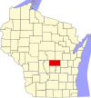
|
| Winnebago County | 139 | Oshkosh | 1840 | unorganized territory | Winnebago nation of Native Americans | &0000000000166994000000166.994 | &0000000000000439000000439 sq mi (&00000000000011370000001.137 km2) | 
|
| Wood County | 141 | Wisconsin Rapids | 1856 | Portage County | Joseph Wood (1809-1890), state legislator (1856-1858) | &000000000007474900000074.749 | &0000000000000793000000793 sq mi (&00000000000020540000002.054 km2) |  |
Tham khảo
- ^ “EPA County FIPS Code Listing”. US Environmental Protection Agency. Truy cập ngày 11 tháng 2 năm 2008.
- ^ a b c d “NACo - Find a county”. National Association of Counties. Bản gốc lưu trữ ngày 24 tháng 10 năm 2007. Truy cập ngày 11 tháng 2 năm 2008.
- ^ a b c “WCA: County Directory”. Wisconsin Counties Association. Bản gốc lưu trữ ngày 11 tháng 2 năm 2008. Truy cập ngày 11 tháng 2 năm 2008.
- ^ a b “Wisconsin QuickFacts”. U.S. Census Bureau. Bản gốc lưu trữ ngày 2 tháng 9 năm 2012. Truy cập ngày 11 tháng 2 năm 2008. (2000 Census)
- ^ Elkins, Winston (1985). Trempealeau and the Mississippi River Dam. Trempealeau County, WI: Trempealeau County Historical Society.
Bản mẫu:U.S. Counties


