Tamano
City in Chūgoku, Japan
Tamano  Flag  Seal | |
|---|---|
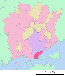
 Location of Tamano in Okayama Prefecture | |
 | |
| Symbols | |
| Fish | "Sebastes inermis" (Mebaru in Japanese) |
| Flower | Azalea |
| Tree | Quercus |


Tamano (玉野市, Tamano-shi) is a city located in southern Okayama Prefecture, Japan. As of 31 October 2022[update], the city had an estimated population of 55,889 in 27087 households, and a population density of 540 persons per km2 .[1] Its total area is 103.58 square kilometres (39.99 sq mi)
Geography
Tamano is located in southern Okayama Prefecture. It faces the Seto Inland Sea to the south, and parts of the city are within the borders of the Setonaikai National Park.
Adjoining municipalities
Okayama Prefecture
- Okayama
- Kurashiki
Climate
Tamano has a humid subtropical climate (Köppen climate classification Cfa). The average annual temperature in Tamano is 16.1 °C (61.0 °F). The average annual rainfall is 1,038.5 mm (40.89 in) with July as the wettest month. The temperatures are highest on average in August, at around 28.1 °C (82.6 °F), and lowest in January, at around 5.5 °C (41.9 °F).[2] The highest temperature ever recorded in Tamano was 38.2 °C (100.8 °F) on 19 August 1995; the coldest temperature ever recorded was −6.4 °C (20.5 °F) on 26 February 1981.[3]
| Climate data for Tamano (1991−2020 normals, extremes 1976−present) | |||||||||||||
|---|---|---|---|---|---|---|---|---|---|---|---|---|---|
| Month | Jan | Feb | Mar | Apr | May | Jun | Jul | Aug | Sep | Oct | Nov | Dec | Year |
| Record high °C (°F) | 17.2 (63.0) | 19.8 (67.6) | 22.7 (72.9) | 29.0 (84.2) | 32.3 (90.1) | 34.1 (93.4) | 37.1 (98.8) | 38.2 (100.8) | 37.1 (98.8) | 31.5 (88.7) | 26.0 (78.8) | 20.9 (69.6) | 38.2 (100.8) |
| Mean daily maximum °C (°F) | 9.2 (48.6) | 9.7 (49.5) | 13.0 (55.4) | 18.1 (64.6) | 22.9 (73.2) | 26.0 (78.8) | 30.3 (86.5) | 32.1 (89.8) | 28.6 (83.5) | 23.1 (73.6) | 17.2 (63.0) | 11.7 (53.1) | 20.2 (68.3) |
| Daily mean °C (°F) | 5.5 (41.9) | 5.8 (42.4) | 8.8 (47.8) | 13.7 (56.7) | 18.5 (65.3) | 22.2 (72.0) | 26.3 (79.3) | 28.1 (82.6) | 24.7 (76.5) | 19.0 (66.2) | 13.1 (55.6) | 7.9 (46.2) | 16.1 (61.0) |
| Mean daily minimum °C (°F) | 2.0 (35.6) | 2.0 (35.6) | 4.6 (40.3) | 9.5 (49.1) | 14.6 (58.3) | 19.2 (66.6) | 23.5 (74.3) | 25.2 (77.4) | 21.4 (70.5) | 15.3 (59.5) | 9.2 (48.6) | 4.3 (39.7) | 12.6 (54.6) |
| Record low °C (°F) | −4.0 (24.8) | −6.4 (20.5) | −5.1 (22.8) | 0.1 (32.2) | 5.7 (42.3) | 10.4 (50.7) | 17.5 (63.5) | 18.3 (64.9) | 11.6 (52.9) | 5.8 (42.4) | 1.7 (35.1) | −3.5 (25.7) | −6.4 (20.5) |
| Average precipitation mm (inches) | 35.5 (1.40) | 42.9 (1.69) | 77.9 (3.07) | 78.7 (3.10) | 103.1 (4.06) | 146.2 (5.76) | 152.5 (6.00) | 78.3 (3.08) | 137.4 (5.41) | 97.4 (3.83) | 48.4 (1.91) | 40.3 (1.59) | 1,038.5 (40.89) |
| Average precipitation days (≥ 1.0 mm) | 5.4 | 6.5 | 9.1 | 9.0 | 8.8 | 10.7 | 9.1 | 5.6 | 8.5 | 7.3 | 5.9 | 5.8 | 91.7 |
| Mean monthly sunshine hours | 158.5 | 152.4 | 182.3 | 202.1 | 212.7 | 166.2 | 203.6 | 237.8 | 171.1 | 179.1 | 161.6 | 159.8 | 2,187.1 |
| Source: Japan Meteorological Agency[3][2] | |||||||||||||
Demographics
Per Japanese census data, the population of Tamano in 2020 is 56,531 people.[4] Tamano has been conducting censuses since 1920.
|
| |||||||||||||||||||||||||||||||||||||||||||||||||||||||||||||||||||||
| Tamano population statistics[4] | ||||||||||||||||||||||||||||||||||||||||||||||||||||||||||||||||||||||
History
The Tamano area is part of ancient Bizen Province. During the Edo Period, it was part of the holdings of Okayama Domain. Following the Meiji restoration, the area was organized into villages within Kojima District, Okayama with the creation of the modern municipalities system on April 1, 1889. The city of Tamano was officially founded on August 3, 1940 by the merger of the towns of Uno and Hibi.
Government
Tamano has a mayor-council form of government with a directly elected mayor and a unicameral city council of 19 members. Tamano contributes two members to the Okayama Prefectural Assembly. In terms of national politics, the city is part of the Okayama 2nd district of the lower house of the Diet of Japan.
Economy
Tamano has a mixed economy of heavy industry, commercial fishing and agriculture. Shipbuilding and metal refining are major industries, with one of the largest shipbuilding yards in Japan, operated by Mitsui Engineering & Shipbuilding, is located in Tamano. Other industries include textiles, chemicals, oil refining and salt production.
Education
Tamano has 14 public elementary schools, seven public junior high schools and two public high schools operated by the city government, and two public high schools operated by the Okayama prefectural Board of Education.
Transportation
The JR Uno Line connects it to Okayama. Before the Great Seto Bridge was opened, there was a train ferry between Uno Port in Tamano and Takamatsu on Shikoku. Then, Tamano was the major entrance to Shikoku. Today there still exist many ferry lines between Uno port and Takamatsu, and also the islands of Shōdoshima and Naoshima.
Railway
Highways


Sister city relations
 - Tongyeong, South Gyeongsang, Republic of Korea since August 3, 1981 [5]
 - Jiujiang, Jiangxi , China, friendship city since 1996 [6]
 - Gloucester, Massachusetts, United States, since July 23, 2004


Notable people from Tamano
- Yukari Ichijo, manga artist
- Hisaichi Ishii, manga artist
- Ukita Kōkichi, aviation pioneer
- Taiyo Sugiura, actor
- Tetsuo Takashima, author
- Katsuya Terada, artist
- Hiroshi Yagi, baseball player
References
- ^ "Tamano city official statistics" (in Japanese). Japan.
- ^ a b 気象庁 / 平年値(年・月ごとの値). JMA. Retrieved May 5, 2022.
- ^ a b 観測史上1~10位の値(年間を通じての値). JMA. Retrieved May 5, 2022.
- ^ a b Tamano population statistics
- ^ "About Tongyeong -> Sister Cities". tongyeong.go.kr. Tongyeong. Retrieved 2020-04-13.
- ^ "Sister Cities". jiujiang.gov.cn. Jiujiang. Retrieved 2020-07-12.
External links
Wikivoyage has a travel guide for Tamano.
 Media related to Tamano, Okayama at Wikimedia Commons
- Tamano City official website (in Japanese)


Authority control databases | |
|---|---|
| International |
|
| National |
|
| Geographic |
|
| Academics |
|
 | This Okayama Prefecture location article is a stub. You can help Wikipedia by expanding it. |
- v
- t
- e


