Szabadegyháza
Place in Fejér, Hungary

Coat of arms
 Hungary
 (2004)
2432
Szabadegyháza is a village in Fejér county, Hungary.
History
Szabadegyháza's history dates back to Roman times, with evidence of Roman presence found in archaeological excavations, including tomb covers, ceramic fragments, bronze fibulae, and coins. The region was known to the Romans, intersecting the Intercisa (Dunaújváros) - Gorsium (Tác) route.[1]
Before the Hungarian conquest, the area was already familiar, evidenced by the discovery of a warrior's grave from the Hungarian conquest era in 1965. The village name, initially recorded in a donation letter on November 20, 1659, mentioned owners like Bossányi Gábor, Eölbey Márton, and Szeghy Mihály.[1]
Changing ownership over time, the village played a minor role in the 1848/49 revolution, providing provisions to the Hungarian camp. Population growth began in the 1800s, reaching 1,111 residents in 1910. During World War I, 215 men were called for military service, with eight casualties. In World War II, many young men from the village fought on the front, but fortunately, no battles occurred within the village.[1]
Becoming an independent municipality in 1926, Szolgaegyháza acquired its current administrative boundaries in 1929. In 1948, it was renamed Szabadegyháza through a decree by the Ministry of Interior (181.321/1948), effective from June 1, 1948.[1]
Gallery
-
 The map of Szabadegyháza from the First Military Mapping Survey of Austria Empire.
 -
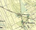 The map of Szabadegyháza from the Second Military Mapping Survey of Austria Empire.
 -
 The map of Szabadegyháza from the 3rd Military Mapping Survey of Austria Empire.


Localities
References
- ^ a b c d "Szabadegyháza története". www.szabadegyhaza.hu (in Hungarian). Retrieved 2023-12-03.
External links
 Media related to Szabadegyháza at Wikimedia Commons
- Street map (in Hungarian)
- v
- t
- e
- Dunaújváros
- Székesfehérvár (county seat)


- Alap
- Alcsútdoboz
- Alsószentiván
- Bakonycsernye
- Bakonykúti
- Balinka
- Baracs
- Baracska
- Beloiannisz
- Besnyő
- Bodmér
- Csabdi
- Csákberény
- Csókakő
- Csősz
- Csór
- Daruszentmiklós
- Dég
- Fehérvárcsurgó
- Felcsút
- Füle
- Gánt
- Gyúró
- Hantos
- Igar
- Iszkaszentgyörgy
- Isztimér
- Iváncsa
- Jenő
- Kajászó
- Káloz
- Kápolnásnyék
- Kincsesbánya
- Kisapostag
- Kisláng
- Kulcs
- Kőszárhegy
- Lovasberény
- Magyaralmás
- Mány
- Mátyásdomb
- Mezőkomárom
- Mezőszentgyörgy
- Mezőszilas
- Moha
- Nadap
- Nádasdladány
- Nagykarácsony
- Nagylók
- Nagyveleg
- Nagyvenyim
- Óbarok
- Pákozd
- Pátka
- Pázmánd
- Pusztavám
- Ráckeresztúr
- Sáregres
- Sárkeresztes
- Sárkeresztúr
- Sárkeszi
- Sárszentágota
- Sárszentmihály
- Söréd
- Sukoró
- Szabadegyháza
- Szabadhídvég
- Szár
- Tabajd
- Tác
- Tordas
- Újbarok
- Úrhida
- Vajta
- Vál
- Vereb
- Vértesacsa
- Vértesboglár
- Zámoly
- Zichyújfalu
- History
- Geography
- Government
- Economy
- Culture
- Tourism
 | This Fejér location article is a stub. You can help Wikipedia by expanding it. |
- v
- t
- e


