Rural Municipality of Alonsa
Rural municipality in Manitoba, Canada
Rural municipality in Manitoba, Canada
50°47′59″N 98°58′36″W / 50.7996°N 98.9766°W / 50.7996; -98.9766Tim Stott
Travis Turko
Michael Brown
Terry Dayholos
Logan Dumanske
(2016)[2]
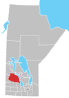
Alonsa is a rural municipality (RM) in the province of Manitoba, western Canada. It lies on the west side of Lake Manitoba.[2]
Located within the borders of the municipality is the Indian reserve of Ebb and Flow 52, as well as the 60,000 m2 (6 ha) Margaret Bruce Beach Provincial Park, located 12 km (7.5 mi) east of the town of Alonsa, on one of a series of sand ridges that extend the length of the west side lake. The park is currently under lease to a private operator but development plans include a provincial campground and day use facility.[3]
The incorporation of Alonsa on 1 January 1945 was as a Local Government District (LGD). It received rural municipality status on 1 January 1997.
Communities
- Alonsa
- Amaranth
- Bacon Ridge
- Bluff Creek
- Cayer
- Eddystone
- Harcus
- Kinosota (Manitoba House)
- Leifur
- Lonely Lake
- Moore Dale
- Portia
- Reedy Creek
- Reykjavik (Icelandic: Reykjavík)
- Shergrove
- Silver Ridge
Demographics
In the 2021 Census of Population conducted by Statistics Canada, Alonsa had a population of 1,210 living in 492 of its 659 total private dwellings, a change of -3% from its 2016 population of 1,247. With a land area of 3,006.17 km2 (1,160.69 sq mi), it had a population density of 0.4/km2 (1.0/sq mi) in 2021.[4]
References
- ^ "Members". April 22, 2017.
- ^ a b "Manitoba Communities: Alonsa (Rural Municipality)".
- ^ Margaret Bruce Recreation Parks, Planning Section 3, Gov of Manitoba Conservation
- ^ "Population and dwelling counts: Canada, provinces and territories, and census subdivisions (municipalities), Manitoba". Statistics Canada. February 9, 2022. Retrieved February 20, 2022.
External links
- Rural Municipality of Alonsa
- Manitoba Historical Society – Rural Municipality of Alonsa
- Map of Alonsa R.M. at Statcan
Places adjacent to Rural Municipality of Alonsa | ||||||||||||||||
|---|---|---|---|---|---|---|---|---|---|---|---|---|---|---|---|---|
| ||||||||||||||||


- v
- t
- e
| Former towns |
|---|
| Former villages |
|---|
| Former RMs |
|---|
- Ebb and Flow
- Keeseekoowenin (Partly)
- Alonsa
- Amaranth
- Ashville
- Bacon Ridge
- Bluff Creek
- Cayer
- East Bay
- Eddystone
- Fork River
- Freedale
- Garland
- Glencairn
- Halicz
- Harcus
- Keld
- Kinosota
- Laurier
- Lonely Lake
- Magnet
- Makinak
- Manitoba House
- Meharry
- Million
- Mink Creek
- Moore Dale
- Moose Bay
- Norgate
- North Junction
- Oak Brae
- Ochre River
- Paulson
- Portia
- Reedy Creek
- Reeve
- Reykjavik
- Rorketon
- Ste. Amélie
- Shergrove
- Sifton
- Silver Ridge
- Toutes Aides
- Trembowla
- Valley River
- Valpoy
- Venlaw
- Volga
- Weiden
- Zoria

 | This Manitoba location article is a stub. You can help Wikipedia by expanding it. |
- v
- t
- e


