Rivello
You can help expand this article with text translated from the corresponding article in Italian. (June 2013) Click [show] for important translation instructions.
- Machine translation, like DeepL or Google Translate, is a useful starting point for translations, but translators must revise errors as necessary and confirm that the translation is accurate, rather than simply copy-pasting machine-translated text into the English Wikipedia.
- Do not translate text that appears unreliable or low-quality. If possible, verify the text with references provided in the foreign-language article.
- You must provide copyright attribution in the edit summary accompanying your translation by providing an interlanguage link to the source of your translation. A model attribution edit summary is
Content in this edit is translated from the existing Italian Wikipedia article at [[:it:Rivello]]; see its history for attribution. - You may also add the template
{{Translated|it|Rivello}}to the talk page. - For more guidance, see Wikipedia:Translation.
Comune in Basilicata, Italy
Rivello | |
|---|---|
Comune | |
| Comune di Rivello | |
 | |
Location of Rivello  | |
40°5′N 15°46′E / 40.083°N 15.767°E / 40.083; 15.767 | |
| Country | Italy |
| Region | Basilicata |
| Province | Potenza (PZ) |
| Frazioni | Rotale, San Costantino, Vignale-Santa Margherita, Medichetta, Sorba, Sovereto, Fiumicello, Asprina, Samprena |
| Area | |
| • Total | 68 km2 (26 sq mi) |
| Elevation | 479 m (1,572 ft) |
| Population (March 2024)[2] | |
| • Total | 2,515 |
| • Density | 37/km2 (96/sq mi) |
| Demonym | Rivellesi |
| Time zone | UTC+1 (CET) |
| • Summer (DST) | UTC+2 (CEST) |
| Postal code | 85040 |
| Dialing code | 0973 |
| ISTAT code | 076068 |
| Patron saint | san Nicola di Bari |
| Saint day | 6 December |
| Website | Official website |
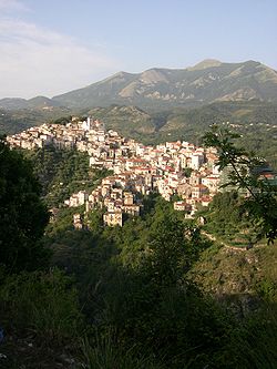
Rivello (Rëviell in the local dialect[4]) is a town and comune in the province of Potenza, in the Southern Italian region of Basilicata. The population was 2,515 as of March 2024[5].
Geography
Territory
The town sits at a median 479 meters above sea level. The comune extends for 68 square km, bordering Casaletto Spartano and Lagonegro to the north, Nemoli to the east, Maratea and Trecchina to the south, and Sapri to the west.
Climate
The closest weather station is that of Maratea. Based on weather reports from 1961-1990, the lowest average temperature is in January at 8.7 °C, while the highest is in August at 23.4 °C[6].
References
- ^ "Superficie di Comuni Province e Regioni italiane al 9 ottobre 2011". Italian National Institute of Statistics. Retrieved 16 March 2019.
- ^ "Popolazione Residente al 1° Gennaio 2018". Italian National Institute of Statistics. Retrieved 16 March 2019.
- ^ dati ufficiali del portale cartografico nazionale del ministero dell'ambiante[permanent dead link]
- ^ AA. VV., Dizionario di toponomastica. Storia e significato dei nomi geografici italiani., Milano, Garzanti, 1996, p. 539, ISBN 88-11-30500-4.
- ^ "Istituto Nazione di Statistica". June 29, 2024.
{{cite web}}: CS1 maint: url-status (link) - ^ Tabella climatica mensile e annuale (TXT), in Archivio climatico DBT, ENEA (archiviato dall'url originale il 2016 circa).
- v
- t
- e
- Abriola
- Acerenza
- Albano di Lucania
- Anzi
- Armento
- Atella
- Avigliano
- Balvano
- Banzi
- Baragiano
- Barile
- Bella
- Brienza
- Brindisi Montagna
- Calvello
- Calvera
- Campomaggiore
- Cancellara
- Carbone
- Castelgrande
- Castelluccio Inferiore
- Castelluccio Superiore
- Castelmezzano
- Castelsaraceno
- Castronuovo di Sant'Andrea
- Cersosimo
- Chiaromonte
- Corleto Perticara
- Episcopia
- Fardella
- Filiano
- Forenza
- Francavilla in Sinni
- Gallicchio
- Genzano di Lucania
- Ginestra
- Grumento Nova
- Guardia Perticara
- Lagonegro
- Latronico
- Laurenzana
- Lauria
- Lavello
- Maratea
- Marsico Nuovo
- Marsicovetere
- Maschito
- Melfi
- Missanello
- Moliterno
- Montemilone
- Montemurro
- Muro Lucano
- Nemoli
- Noepoli
- Oppido Lucano
- Palazzo San Gervasio
- Paterno
- Pescopagano
- Picerno
- Pietragalla
- Pietrapertosa
- Pignola
- Potenza
- Rapolla
- Rapone
- Rionero in Vulture
- Ripacandida
- Rivello
- Roccanova
- Rotonda
- Ruoti
- Ruvo del Monte
- San Chirico Nuovo
- San Chirico Raparo
- San Costantino Albanese
- San Fele
- San Martino d'Agri
- San Paolo Albanese
- San Severino Lucano
- Sant'Angelo Le Fratte
- Sant'Arcangelo
- Sarconi
- Sasso di Castalda
- Satriano di Lucania
- Savoia di Lucania
- Senise
- Spinoso
- Teana
- Terranova di Pollino
- Tito
- Tolve
- Tramutola
- Trecchina
- Trivigno
- Vaglio Basilicata
- Venosa
- Vietri di Potenza
- Viggianello
- Viggiano
Authority control databases | |
|---|---|
| International |
|
| Geographic |
|
 | This Basilicata location article is a stub. You can help Wikipedia by expanding it. |
- v
- t
- e


