Nuckro Water
Shetland loch
60°21′05″N 0°58′16″W / 60.35143°N 0.970983°W / 60.35143; -0.970983
Nuckro Water is a loch of southeastern Whalsay, Shetland Islands, Scotland. It is located to the east of the Loch of Stanefield, northwest of Treawick and southwest of Isbister, and passes by the main road on its eastern side.[1] Also known as Nuckra, Nyker, or Nyuggle, the name comes from the water spirit said to haunt lonely places. There is a disused quarry just to the northeast and the remains of a prehistoric house nearby. On the southeastern side, across the road near the source of Falsa Burn is an unroofed building, which was probably used as a mill; it was shown on the 1st OS map of Orkney and Shetland in 1882.[2] In the southeastern corner of the loch there are stepping stones across the water.
-
 Looking west across the frozen Nuckro Water
 -
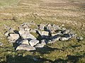 Prehistoric house


References
- ^ "Nuckro Water, HU 569 635 GB Grid". Ordnance Survey. Retrieved 3 February 2013.
- ^ "Site Record for Whalsay, Nuckro Water". Royal Commission on the Ancient and Historical Monuments of Scotland. Retrieved 3 February 2013.
- v
- t
- e
Whalsay

- Bays, cliffs, and headlands: List of coastal features of Whalsay
- Linga Sound
- Islets: East Linga
- Holm of Sandwick
- Inner Holm of Skaw
- Isbister Holm
- Mooa
- Nista
- Outer Holm of Skaw
- Rumble
- Skate of Marrister
- West Linga
- Hills: Setter Hill
- Lochs: Little Water
- Loch of Houll
- Loch of Huxter
- Loch of Isbister
- Loch of Livister
- Loch of Sandwick
- Loch of Stanefield
- Loch of Vats-houll
- Nuckro Water
- East Loch of Skaw
- West Loch of Skaw
- Streams: Breiwick Burn
- Falsa Burn
- Scarfmoor Burn
 | This Shetland location article is a stub. You can help Wikipedia by expanding it. |
- v
- t
- e


