National Register of Historic Places listings in Miami

This is a list of the National Register of Historic Places listings in Miami, Florida.
This is intended to be a complete list of the properties and districts on the National Register of Historic Places in Miami, Florida, United States. The locations of National Register properties and districts for which the latitude and longitude coordinates are included below, may be seen in an online map.[1]
There are 193 properties and districts listed on the National Register in Miami-Dade County, including 6 National Historic Landmarks. Miami is the location of 79 of these properties and districts, including 5 National Historic Landmarks; they are listed here, while the remaining properties and districts are listed separately. One property, the Venetian Causeway, is split between Miami and Miami Beach, and is thus included on both lists. Another 3 sites were once listed, but have been removed.
This National Park Service list is complete through NPS recent listings posted May 10, 2024.[2]
Map all coordinates using OpenStreetMap
Download coordinates as:
- KML
- GPX (all coordinates)
- GPX (primary coordinates)
- GPX (secondary coordinates)
| Alachua - Baker - Bay - Bradford - Brevard - Broward - Calhoun - Charlotte - Citrus - Clay - Collier - Columbia - DeSoto - Dixie - Duval - Escambia - Flagler - Franklin - Gadsden - Gilchrist - Glades - Gulf - Hamilton - Hardee - Hendry - Hernando - Highlands - Hillsborough (Tampa) - Holmes - Indian River - Jackson - Jefferson - Lafayette - Lake - Lee - Leon - Levy - Liberty - Madison - Manatee - Marion - Martin - Miami-Dade (Miami) - Monroe - Nassau - Okaloosa - Okeechobee - Orange - Osceola - Palm Beach - Pasco - Pinellas - Polk - Putnam - St. Johns - St. Lucie - Santa Rosa - Sarasota - Seminole - Sumter - Suwannee - Taylor - Union - Volusia - Wakulla - Walton - Washington |
Current listings
| [3] | Name on the Register[4] | Image | Date listed[5] | Location | City or town | Description |
|---|---|---|---|---|---|---|
| 1 | Ace Theatre |  | June 13, 2016 (#16000359) | 3664 Grand Ave. 25°43′39″N 80°15′10″W / 25.727592°N 80.252810°W / 25.727592; -80.252810 (Ace Theatre) | ||
| 2 | Atlantic Gas Station | 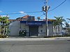 | December 29, 1988 (#88003060) | 668 Northwest 5th Street 25°46′41″N 80°12′22″W / 25.778056°N 80.206111°W / 25.778056; -80.206111 (Atlantic Gas Station) | Part of the Downtown Miami MRA | |
| 3 | Bacardi Complex |  | October 16, 2018 (#100003017) | 2100 Biscayne Blvd. 25°47′51″N 80°11′22″W / 25.7974°N 80.1894°W / 25.7974; -80.1894 (Bacardi Complex) | ||
| 4 | Barracks and Mess Building-US Coast Guard Air Station at Dinner Key | 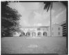 | August 10, 1995 (#95000816) | 2610 Tigertail Avenue 25°43′55″N 80°14′07″W / 25.731944°N 80.235278°W / 25.731944; -80.235278 (Barracks and Mess Building-US Coast Guard Air Station at Dinner Key) | ||
| 5 | Bay Shore Historic District |  | October 2, 1992 (#92001323) | Roughly bounded by Northeast 55th Street, Biscayne Boulevard, Northeast 60th Street, and Biscayne Bay 25°49′46″N 80°10′57″W / 25.829319°N 80.182625°W / 25.829319; -80.182625 (Bay Shore Historic District) | ||
| 6 | Brickell Mausoleum |  | January 4, 1989 (#88002977) | 501 Brickell Avenue 25°46′05″N 80°11′30″W / 25.768056°N 80.191667°W / 25.768056; -80.191667 (Brickell Mausoleum) | Part of the Downtown Miami MRA | |
| 7 | Brickell Point Site |  | February 5, 2002 (#01001534) | 401 Brickell Ave 25°46′08″N 80°11′21″W / 25.768889°N 80.189167°W / 25.768889; -80.189167 (Brickell Point Site) | ||
| 8 | William Jennings Bryan House | 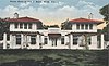 | January 20, 2012 (#11001029) | 3115 Brickell Ave 25°44′55″N 80°12′22″W / 25.748569°N 80.206053°W / 25.748569; -80.206053 (William Jennings Bryan House) | ||
| 9 | Central Baptist Church |  | January 4, 1989 (#88002988) | 500 Northeast 1st Avenue 25°46′31″N 80°11′31″W / 25.775278°N 80.191944°W / 25.775278; -80.191944 (Central Baptist Church) | Part of the Downtown Miami MRA | |
| 10 | City National Bank Building |  | January 4, 1989 (#88002975) | 121 Southeast 1st Street 25°46′30″N 80°11′30″W / 25.775°N 80.191667°W / 25.775; -80.191667 (City National Bank Building) | Part of the Downtown Miami MRA | |
| 11 | City of Miami Cemetery |  | January 4, 1989 (#88002960) | 1800 Northeast 2nd Avenue 25°47′38″N 80°11′27″W / 25.793889°N 80.190833°W / 25.793889; -80.190833 (City of Miami Cemetery) | Part of the Downtown Miami MRA | |
| 12 | Coconut Grove Library |  | May 1, 2017 (#100000932) | 2875 McFarlane Rd. 25°43′36″N 80°14′26″W / 25.726641°N 80.240608°W / 25.726641; -80.240608 (Coconut Grove Library) | ||
| 13 | Coconut Grove Playhouse |  | October 19, 2018 (#100003018) | 3500 Main Hwy 25°43′32″N 80°14′41″W / 25.7255°N 80.2447°W / 25.7255; -80.2447 (Coconut Grove Playhouse) | ||
| 14 | Congress Building | 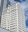 | March 14, 1985 (#85000553) | 111 Northeast 2nd Avenue 25°46′31″N 80°11′24″W / 25.775278°N 80.19°W / 25.775278; -80.19 (Congress Building) | ||
| 15 | Dade County Courthouse |  | January 4, 1989 (#88002983) | 73 West Flagler Street 25°46′27″N 80°11′43″W / 25.774167°N 80.195278°W / 25.774167; -80.195278 (Dade County Courthouse) | Part of the Downtown Miami MRA | |
| 16 | D. A. Dorsey House | 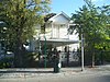 | January 4, 1989 (#88002966) | 250 Northwest 9th Street 25°46′57″N 80°11′56″W / 25.7825°N 80.198889°W / 25.7825; -80.198889 (D. A. Dorsey House) | Part of the Downtown Miami MRA | |
| 17 | Marjory Stoneman Douglas House |  | February 27, 2015 (#15000312) | 3744 Stewart Ave. 25°42′40″N 80°15′13″W / 25.711°N 80.2535°W / 25.711; -80.2535 (Marjory Stoneman Douglas House) | Home of environmentalist and activist Marjory Stoneman Douglas | |
| 18 | Downtown Miami Historic District |  | December 6, 2005 (#05001356) | Roughly bounded by Miami Ct., 3rd Street, 3rd Avenue, and 2nd Street 25°46′21″N 80°11′31″W / 25.77255°N 80.191839°W / 25.77255; -80.191839 (Downtown Miami Historic District) | ||
| 19 | Alfred I. DuPont Building |  | January 4, 1989 (#88002984) | 169 East Flagler Street 25°46′28″N 80°11′26″W / 25.7745°N 80.1906°W / 25.7745; -80.1906 (Alfred I. DuPont Building) | Part of the Downtown Miami MRA | |
| 20 | El Jardin |  | August 30, 1974 (#74000614) | 3747 Main Highway 25°43′18″N 80°14′54″W / 25.721667°N 80.248333°W / 25.721667; -80.248333 (El Jardin) | ||
| 21 | Fire Station No. 2 |  | January 4, 1989 (#88002971) | 1401 North Miami Avenue 25°47′17″N 80°11′41″W / 25.788056°N 80.194722°W / 25.788056; -80.194722 (Fire Station No. 2) | Part of the Downtown Miami MRA | |
| 22 | Fire Station No. 4 |  | March 8, 1984 (#84000836) | 1000 South Miami Avenue 25°45′51″N 80°11′36″W / 25.764167°N 80.193333°W / 25.764167; -80.193333 (Fire Station No. 4) | ||
| 23 | First Coconut Grove School |  | January 21, 1975 (#75000547) | 3429 Devon Road 25°43′19″N 80°14′55″W / 25.721944°N 80.248611°W / 25.721944; -80.248611 (First Coconut Grove School) | ||
| 24 | Flori-Coral Apartments | Upload image | April 20, 2023 (#100008861) | 1250 SW 6 St. 25°46′03″N 80°12′56″W / 25.767443°N 80.215532°W / 25.767443; -80.215532 (Flori-Coral Apartments) | ||
| 25 | Florida East Coast Railway Locomotive No. 153 |  | February 21, 1985 (#85000303) | 12400 Southwest 152nd Street 25°37′15″N 80°24′22″W / 25.620833°N 80.406111°W / 25.620833; -80.406111 (Florida East Coast Railway Locomotive No. 153) | ||
| 26 | Freedom Tower |  | September 10, 1979 (#79000665) | 600 Biscayne Boulevard 25°46′48″N 80°11′23″W / 25.78°N 80.189722°W / 25.78; -80.189722 (Freedom Tower) | ||
| 27 | Gesu Church | 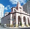 | July 18, 1974 (#74000617) | 118 Northeast 2nd Street 25°46′32″N 80°11′31″W / 25.775556°N 80.191944°W / 25.775556; -80.191944 (Gesu Church) | ||
| 28 | Greater Bethel AME Church |  | April 17, 1992 (#88002987) | 245 Northwest 8th Street 25°46′54″N 80°11′57″W / 25.781667°N 80.199167°W / 25.781667; -80.199167 (Greater Bethel AME Church) | Part of the Downtown Miami MRA | |
| 29 | Grove Park Historic District | Upload image | December 8, 2023 (#100008869) | Bounded by NW 17th Ave., FL 836, NW 14th Ct., and NW 7th St. 25°46′53″N 80°13′16″W / 25.781322°N 80.221202°W / 25.781322; -80.221202 (Grove Park Historic District) | ||
| 30 | Hahn Building |  | January 4, 1989 (#88002989) | 140 Northeast 1st Avenue 25°46′32″N 80°11′32″W / 25.775556°N 80.192222°W / 25.775556; -80.192222 (Hahn Building) | Part of the Downtown Miami MRA | |
| 31 | HALF MOON (shipwreck) |  | May 31, 2001 (#01000531) | Outside Bear Cut off Key Biscayne 25°43′39″N 80°08′04″W / 25.7275°N 80.134444°W / 25.7275; -80.134444 (HALF MOON (shipwreck)) | ||
| 32 | Halissee Hall |  | October 1, 1974 (#74000618) | 1700 Northwest 10th Avenue 25°47′17″N 80°12′53″W / 25.788056°N 80.214722°W / 25.788056; -80.214722 (Halissee Hall) | ||
| 33 | Hampton House Motel | Upload image | February 7, 2022 (#100007393) | 4240 NW 27th Ave. 25°48′51″N 80°14′26″W / 25.8142°N 80.2406°W / 25.8142; -80.2406 (Hampton House Motel) | ||
| 34 | Huntington Building |  | January 4, 1989 (#88002976) | 168 Southeast 1st Street 25°46′28″N 80°11′27″W / 25.774444°N 80.190833°W / 25.774444; -80.190833 (Huntington Building) | Part of the Downtown Miami MRA | |
| 35 | Ingraham Building |  | January 4, 1989 (#88002958) | 25 Southeast 2nd Avenue 25°46′23″N 80°11′25″W / 25.773056°N 80.190278°W / 25.773056; -80.190278 (Ingraham Building) | Part of the Downtown Miami MRA | |
| 36 | J & S Building |  | January 4, 1989 (#88002967) | 221–233 Northwest 9th Street 25°46′55″N 80°11′53″W / 25.781944°N 80.198056°W / 25.781944; -80.198056 (J & S Building) | Part of the Downtown Miami MRA | |
| 37 | Dr. James M. Jackson Office |  | February 24, 1975 (#75000550) | 190 Southeast 12th Terrace 25°45′39″N 80°11′25″W / 25.760833°N 80.190278°W / 25.760833; -80.190278 (Dr. James M. Jackson Office) | ||
| 38 | The Kampong |  | March 1, 1984 (#84000837) | Address Restricted 25°43′01″N 80°15′11″W / 25.716944°N 80.253056°W / 25.716944; -80.253056 (The Kampong) | ||
| 39 | Kentucky Home | 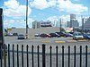 | January 4, 1989 (#88002969) | 1221 and 1227 Northeast 1st Avenue 25°47′10″N 80°11′31″W / 25.786111°N 80.191944°W / 25.786111; -80.191944 (Kentucky Home) | Part of the Downtown Miami MRA | |
| 40 | Lincoln Memorial Park Cemetery |  | March 29, 2018 (#100002292) | 3001 NW 46th St 25°48′59″N 80°14′42″W / 25.816351°N 80.245045°W / 25.816351; -80.245045 (Lincoln Memorial Park Cemetery) | ||
| 41 | Lummus Park Historic District | 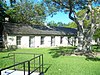 | October 25, 2006 (#06000952) | Roughly bounded by Northwest Second Street, Northwest Third Court, Northwest Fourth Street, and Northwest North River Drive 25°46′37″N 80°12′04″W / 25.77685°N 80.201164°W / 25.77685; -80.201164 (Lummus Park Historic District) | ||
| 42 | Lyric Theater | 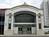 | January 4, 1989 (#88002965) | 819 Northwest 2nd Avenue 25°46′55″N 80°11′53″W / 25.781944°N 80.198056°W / 25.781944; -80.198056 (Lyric Theater) | Part of the Downtown Miami MRA | |
| 43 | Martina Apartments |  | January 4, 1989 (#88002981) | 1023 South Miami Avenue 25°45′49″N 80°11′35″W / 25.763611°N 80.193056°W / 25.763611; -80.193056 (Martina Apartments) | Part of the Downtown Miami MRA | |
| 44 | Meyer-Kiser Building |  | January 4, 1989 (#88002991) | 139 Northeast 1st Building 25°46′30″N 80°11′29″W / 25.775°N 80.191389°W / 25.775; -80.191389 (Meyer-Kiser Building) | Part of the Downtown Miami MRA | |
| 45 | Miami Black Police Precinct and Courthouse | Upload image | February 5, 2020 (#100004974) | 480 NW 11th St. 25°47′04″N 80°12′10″W / 25.7845°N 80.2029°W / 25.7845; -80.2029 (Miami Black Police Precinct and Courthouse) | ||
| 46 | Miami City Hospital, Building No. 1 |  | December 31, 1979 (#79000666) | 1611 Northwest 12th Avenue 25°47′29″N 80°12′45″W / 25.791389°N 80.2125°W / 25.791389; -80.2125 (Miami City Hospital, Building No. 1) | ||
| 47 | Miami Edison Senior High School |  | June 5, 1986 (#86001212) | 6101 Northwest Second Avenue 25°49′53″N 80°12′00″W / 25.831389°N 80.2°W / 25.831389; -80.2 (Miami Edison Senior High School) | ||
| 48 | Miami Marine Stadium |  | April 2, 2018 (#100002293) | 3501 Rickenbacker Causeway 25°44′35″N 80°10′12″W / 25.74295°N 80.169865°W / 25.74295; -80.169865 (Miami Marine Stadium) | ||
| 49 | Miami Senior High School | 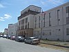 | June 18, 1990 (#90000881) | 2450 Southwest First Street 25°46′17″N 80°14′10″W / 25.771389°N 80.236111°W / 25.771389; -80.236111 (Miami Senior High School) | ||
| 50 | Miami Women's Club | 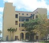 | December 27, 1974 (#74002257) | 1737 North Bayshore Drive 25°47′30″N 80°11′10″W / 25.791667°N 80.186111°W / 25.791667; -80.186111 (Miami Women's Club) | ||
| 51 | Mount Zion Baptist Church |  | December 29, 1988 (#88003059) | 301 Northwest 9th Street 25°46′58″N 80°11′59″W / 25.782824°N 80.199822°W / 25.782824; -80.199822 (Mount Zion Baptist Church) | Part of the Downtown Miami MRA | |
| 52 | Ralph M. Munroe House |  | April 11, 1973 (#73000575) | 3485 Main Highway 25°43′28″N 80°14′33″W / 25.724444°N 80.2425°W / 25.724444; -80.2425 (Ralph M. Munroe House) | ||
| 53 | Naval Air Station Richmond Headquarters Building |  | May 1, 2017 (#100000933) | 12450 SW. 152nd St. 25°37′37″N 80°23′32″W / 25.626855°N 80.392143°W / 25.626855; -80.392143 (Naval Air Station Richmond Headquarters Building) | ||
| 54 | Old US Post Office and Courthouse |  | January 4, 1989 (#88002962) | 100–118 Northeast 1st Avenue 25°46′31″N 80°11′33″W / 25.775278°N 80.1925°W / 25.775278; -80.1925 (Old US Post Office and Courthouse) | Part of the Downtown Miami MRA | |
| 55 | Olympia Theater and Office Building |  | March 8, 1984 (#84000839) | 174 East Flager Street 25°46′25″N 80°11′27″W / 25.773611°N 80.190833°W / 25.773611; -80.190833 (Olympia Theater and Office Building) | ||
| 56 | Palm Cottage |  | January 4, 1989 (#88002957) | 60 Southeast 4th Street 25°46′14″N 80°11′33″W / 25.770556°N 80.1925°W / 25.770556; -80.1925 (Palm Cottage) | Part of the Downtown Miami MRA | |
| 57 | Pan American Seaplane Base and Terminal Building |  | February 20, 1975 (#75000548) | 3500 Pan American Drive 25°43′40″N 80°14′03″W / 25.727778°N 80.234167°W / 25.727778; -80.234167 (Pan American Seaplane Base and Terminal Building) | ||
| 58 | Plymouth Congregational Church |  | July 23, 1974 (#74000615) | 3429 Devon Road 25°43′19″N 80°14′18″W / 25.721944°N 80.238333°W / 25.721944; -80.238333 (Plymouth Congregational Church) | ||
| 59 | Ransom School "Pagoda" | 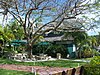 | July 25, 1973 (#73000572) | 3575 Main Highway 25°43′21″N 80°14′04″W / 25.7225°N 80.234444°W / 25.7225; -80.234444 (Ransom School "Pagoda") | ||
| 60 | Richmond Heights Pioneer Historic District | Upload image | March 25, 2019 (#100003405) | 14520-14960 Monroe St. 25°37′53″N 80°22′26″W / 25.6315°N 80.3740°W / 25.6315; -80.3740 (Richmond Heights Pioneer Historic District) | ||
| 61 | S & S Sandwich Shop | 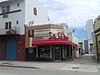 | January 4, 1989 (#88002994) | 1757 Northeast 2nd Street 25°47′33″N 80°11′28″W / 25.7925°N 80.191111°W / 25.7925; -80.191111 (S & S Sandwich Shop) | Part of the Downtown Miami MRA | |
| 62 | St. John's Baptist Church |  | April 17, 1992 (#88002970) | 1328 Northwest 3rd Avenue 25°47′13″N 80°12′01″W / 25.786944°N 80.200278°W / 25.786944; -80.200278 (St. John's Baptist Church) | Part of the Downtown Miami MRA | |
| 63 | Sears, Roebuck and Company Department Store |  | August 8, 1997 (#84003903) | 1300 Biscayne Boulevard 25°47′14″N 80°11′24″W / 25.787222°N 80.19°W / 25.787222; -80.19 (Sears, Roebuck and Company Department Store) | Only a tower building survives, as part of Adrienne Arsht Center for the Performing Arts | |
| 64 | Security Building |  | January 4, 1989 (#88002990) | 117 Northeast 1st Avenue 25°46′31″N 80°11′31″W / 25.775278°N 80.191944°W / 25.775278; -80.191944 (Security Building) | Part of the Downtown Miami MRA | |
| 65 | Shoreland Arcade |  | January 4, 1989 (#88002992) | 120 Northeast 1st Street 25°46′28″N 80°11′29″W / 25.774444°N 80.191389°W / 25.774444; -80.191389 (Shoreland Arcade) | Part of the Downtown Miami MRA | |
| 66 | South River Drive Historic District | 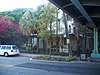 | August 10, 1987 (#87000671) | 428 and 438 Southwest First Street, 437 Southwest Second Street, and 104, 109, and 118 Southwest South River Drive 25°46′20″N 80°12′06″W / 25.772222°N 80.201667°W / 25.772222; -80.201667 (South River Drive Historic District) | ||
| 67 | Southside School | 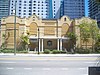 | January 4, 1989 (#88002980) | 45 Southwest 13th Street 25°45′41″N 80°11′58″W / 25.761389°N 80.199444°W / 25.761389; -80.199444 (Southside School) | Part of the Downtown Miami MRA | |
| 68 | Trapp Homestead | 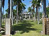 | November 10, 1994 (#94001279) | 2521 South Bayshore Drive 25°44′01″N 80°14′17″W / 25.733611°N 80.238056°W / 25.733611; -80.238056 (Trapp Homestead) | ||
| 69 | Trinity Episcopal Cathedral |  | October 10, 1980 (#80000945) | 464 Northeast 16th Street 25°47′24″N 80°11′12″W / 25.79°N 80.186667°W / 25.79; -80.186667 (Trinity Episcopal Cathedral) | ||
| 70 | U.S. Car No. 1 |  | August 24, 1977 (#77000401) | 3398 Southwest 9th Avenue 25°37′02″N 80°24′02″W / 25.617117°N 80.400647°W / 25.617117; -80.400647 (U.S. Car No. 1) | ||
| 71 | US Coast Guard Air Station Hangar at Dinner Key | 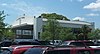 | December 19, 2002 (#02001535) | 2600 South Bayshore Drive 25°43′51″N 80°14′04″W / 25.730833°N 80.234444°W / 25.730833; -80.234444 (US Coast Guard Air Station Hangar at Dinner Key) | ||
| 72 | US Post Office and Courthouse |  | October 14, 1983 (#83003518) | 300 Northeast 1st Avenue 25°46′38″N 80°11′34″W / 25.777222°N 80.192778°W / 25.777222; -80.192778 (US Post Office and Courthouse) | ||
| 73 | Vagabond Motel | 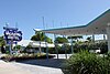 | December 29, 2014 (#14001086) | 7301 Biscayne Blvd. 25°50′34″N 80°11′02″W / 25.842891°N 80.183957°W / 25.842891; -80.183957 (Vagabond Motel) | ||
| 74 | Venetian Causeway |  | July 13, 1989 (#89000852) | Northeast 15th Street and Dade Boulevard 25°47′21″N 80°11′21″W / 25.789167°N 80.189167°W / 25.789167; -80.189167 (Venetian Causeway) | Extends into Miami Beach, elsewhere in Miami-Dade County | |
| 75 | Virginia Key Beach Park | 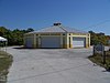 | June 28, 2002 (#02000681) | East of Biscayne Bay and north of the Rickenbacker Causeway 25°44′02″N 80°09′43″W / 25.733889°N 80.161944°W / 25.733889; -80.161944 (Virginia Key Beach Park) | ||
| 76 | Vizcaya | 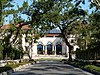 | September 29, 1970 (#70000181) | 3251 South Miami Avenue; also roughly bounded by South Dixie Highway, Southwest 32nd Road, and South Miami Avenue 25°44′37″N 80°12′37″W / 25.743611°N 80.210278°W / 25.743611; -80.210278 (Vizcaya) | Vizcaya was added to the National Register on September 29, 1970 (refnum 70000181), with a boundary increase on November 15, 1978 (refnum 78003193). It was made a National Historic Landmark on April 19, 1994 (refnum 70000181).[6] | |
| 77 | Walgreen Drug Store |  | January 4, 1989 (#88002982) | 200 East Flagler Street 25°46′29″N 80°11′25″W / 25.774722°N 80.190278°W / 25.774722; -80.190278 (Walgreen Drug Store) | Part of the Downtown Miami MRA | |
| 78 | J. W. Warner House |  | June 1, 1983 (#83001419) | 111 Southwest 5th Avenue 25°46′24″N 80°12′10″W / 25.773333°N 80.202778°W / 25.773333; -80.202778 (J. W. Warner House) | ||
| 79 | Woman's Club of Coconut Grove |  | March 26, 1975 (#75000549) | 2985 South Bayshore Drive 25°43′37″N 80°14′24″W / 25.726944°N 80.24°W / 25.726944; -80.24 (Woman's Club of Coconut Grove) |
Former listings
| [3] | Name on the Register | Image | Date listed | Date removed | Location | City or town | Description |
|---|---|---|---|---|---|---|---|
| 1 | Algonquin Apartments |  | January 4, 1989 (#88002985) | July 24, 2018 | 1819–1825 Biscayne Boulevard 25°47′37″N 80°11′20″W / 25.793611°N 80.188889°W / 25.793611; -80.188889 (Algonquin Apartments) | Part of the Downtown Miami MRA | |
| 2 | I. and E. Greenwald Steam Engine No. 1058 |  | March 12, 1987 (#87002197) | July 24, 2018 | 3898 Shipping Avenue 25°43′57″N 80°15′27″W / 25.7325°N 80.2575°W / 25.7325; -80.2575 (I. and E. Greenwald Steam Engine No. 1058) | ||
| 3 | Priscilla Apartments | | January 4, 1989 (#88002986) | July 24, 2018 | 318–320 Northeast 19th Street and 1845 Biscayne Boulevard 25°47′39″N 80°11′20″W / 25.794167°N 80.188889°W / 25.794167; -80.188889 (Priscilla Apartments) | Part of the Downtown Miami MRA |
See also
Wikimedia Commons has media related to National Register of Historic Places in Miami, Florida.
- List of National Historic Landmarks in Florida
- National Register of Historic Places listings in Florida
References
- ^ The latitude and longitude information provided in this table was derived originally from the National Register Information System, which has been found to be fairly accurate for about 99% of listings. Some locations in this table may have been corrected to current GPS standards.
- ^ National Park Service, United States Department of the Interior, "National Register of Historic Places: Weekly List Actions", retrieved May 10, 2024.
- ^ a b Numbers represent an alphabetical ordering by significant words. Various colorings, defined here, differentiate National Historic Landmarks and historic districts from other NRHP buildings, structures, sites or objects.
- ^ "National Register Information System". National Register of Historic Places. National Park Service. March 13, 2009.
- ^ The eight-digit number below each date is the number assigned to each location in the National Register Information System database, which can be viewed by clicking the number.
- ^ "Vizcaya". National Historic Landmark summary listing. National Park Service. Archived from the original on 2007-12-02. Retrieved 2008-06-21.
- v
- t
- e
by county
- Alachua
- Baker
- Bay
- Bradford
- Brevard
- Broward
- Calhoun
- Charlotte
- Citrus
- Clay
- Collier
- Columbia
- DeSoto
- Dixie
- Duval
- Escambia
- Flagler
- Franklin
- Gadsden
- Gilchrist
- Glades
- Gulf
- Hamilton
- Hardee
- Hendry
- Hernando
- Highlands
- Hillsborough
- Holmes
- Indian River
- Jackson
- Jefferson
- Lake
- Lee
- Leon
- Levy
- Liberty
- Madison
- Manatee
- Marion
- Martin
- Miami-Dade
- Monroe
- Nassau
- Okaloosa
- Okeechobee
- Orange
- Osceola
- Palm Beach
- Pasco
- Pinellas
- Polk
- Putnam
- Santa Rosa
- Sarasota
- Seminole
- St. Johns
- St. Lucie
- Sumter
- Suwannee
- Taylor
- Union
- Volusia
- Wakulla
- Walton
- Washington

- Miami
- Tampa
Miami articles | ||
|---|---|---|
| By topic |  | |
| Neighborhoods |
| |
| Government | ||
| Emergency services | ||
| Transportation |
| |
| Culture | ||
| Education | ||
| People | ||


