National Register of Historic Places listings in Bryan County, Oklahoma

This is a list of the National Register of Historic Places listings in Bryan County, Oklahoma.
This is intended to be a complete list of the properties and districts on the National Register of Historic Places in Bryan County, Oklahoma, United States. The locations of National Register properties and districts for which the latitude and longitude coordinates are included below, may be seen in a map.[1]
There are 16 properties and districts listed on the National Register in the county, including 1 National Historic Landmark.
This National Park Service list is complete through NPS recent listings posted June 28, 2024.[2]
Map all coordinates using OpenStreetMap
Download coordinates as:
- KML
- GPX (all coordinates)
- GPX (primary coordinates)
- GPX (secondary coordinates)
Current listings
| [3] | Name on the Register[4] | Image | Date listed[5] | Location | City or town | Description |
|---|---|---|---|---|---|---|
| 1 | Armstrong Academy Site | Upload image | April 13, 1972 (#72001056) | 3 miles northeast of Bokchito 34°03′01″N 96°11′59″W / 34.050278°N 96.199722°W / 34.050278; -96.199722 (Armstrong Academy Site) | Bokchito | |
| 2 | Bloomfield Academy Site | Upload image | November 15, 1972 (#72001055) | South of Achille off State Highway 78 33°47′58″N 96°23′01″W / 33.799444°N 96.383611°W / 33.799444; -96.383611 (Bloomfield Academy Site) | Achille | |
| 3 | Bryan County Courthouse | 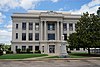 | August 23, 1984 (#84002974) | 4th Ave. and Evergreen St. 33°59′34″N 96°22′52″W / 33.992778°N 96.381111°W / 33.992778; -96.381111 (Bryan County Courthouse) | Durant | |
| 4 | Caddo Community Building | Upload image | September 8, 1988 (#88001376) | E. Buffalo St. 34°07′32″N 96°15′43″W / 34.125556°N 96.261944°W / 34.125556; -96.261944 (Caddo Community Building) | Caddo | |
| 5 | Carriage Point | Upload image | June 29, 1972 (#72001058) | 4 miles west of Durant 33°59′07″N 96°27′16″W / 33.985278°N 96.454444°W / 33.985278; -96.454444 (Carriage Point) | Durant | |
| 6 | Colbert's Ferry Site | Upload image | June 29, 1972 (#72001057) | 3 miles southeast of Colbert 33°49′13″N 96°31′20″W / 33.820278°N 96.522222°W / 33.820278; -96.522222 (Colbert's Ferry Site) | Colbert | |
| 7 | Durant Downtown Historic District |  | June 5, 2007 (#07000517) | Roughly bounded by 4th Ave., Lost St., Evergreen St., and 1st Ave. 33°59′29″N 96°22′43″W / 33.9913°N 96.3787°W / 33.9913; -96.3787 (Durant Downtown Historic District) | Durant | |
| 8 | Fort McCulloch | Upload image | June 21, 1971 (#71000659) | 2 miles southwest of Kenefic 34°07′52″N 96°23′42″W / 34.131111°N 96.395°W / 34.131111; -96.395 (Fort McCulloch) | Kenefic | |
| 9 | Fort Washita |  | October 15, 1966 (#66000626) | Southwest of Nida on State Highway 199 34°06′13″N 96°32′54″W / 34.103611°N 96.548333°W / 34.103611; -96.548333 (Fort Washita) | Nida | |
| 10 | Robert E. Lee School |  | September 8, 1988 (#88001374) | 9th and Louisiana Sts. 33°59′22″N 96°23′09″W / 33.989444°N 96.385833°W / 33.989444; -96.385833 (Robert E. Lee School) | Durant | |
| 11 | Nail's Station | Upload image | June 29, 1972 (#72001059) | 2 miles southwest of Kenefic 34°07′52″N 96°23′26″W / 34.1312°N 96.3905°W / 34.1312; -96.3905 (Nail's Station) | Kenefic | |
| 12 | Oklahoma Presbyterian College |  | December 12, 1976 (#76001556) | 601 N. 16th St. 34°00′00″N 96°23′35″W / 34.0°N 96.393056°W / 34.0; -96.393056 (Oklahoma Presbyterian College) | Durant | |
| 13 | Roberta School Campus | Upload image | September 8, 1988 (#88001377) | Off State Highway 70 33°55′41″N 96°18′13″W / 33.928056°N 96.303611°W / 33.928056; -96.303611 (Roberta School Campus) | Durant | |
| 14 | State Highway 78 Bridge at the Red River |  | December 20, 1996 (#96001517) | State Highway 78, across the Red River at the Oklahoma-Texas state line 33°45′10″N 96°11′45″W / 33.752778°N 96.195833°W / 33.752778; -96.195833 (State Highway 78 Bridge at the Red River) | Kemp | Extends into Fannin County, Texas |
| 15 | Robert Lee Williams Public Library |  | September 8, 1988 (#88001375) | 4th and Beech Sts. 33°59′36″N 96°22′44″W / 33.993333°N 96.378889°W / 33.993333; -96.378889 (Robert Lee Williams Public Library) | Durant | Now the county courthouse annex. |
| 16 | J. L. Wilson Building | 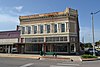 | April 20, 1982 (#82003668) | 202 W. Evergreen St. 33°59′26″N 96°22′48″W / 33.990556°N 96.38°W / 33.990556; -96.38 (J. L. Wilson Building) | Durant |
See also
Wikimedia Commons has media related to National Register of Historic Places in Bryan County, Oklahoma.
- List of National Historic Landmarks in Oklahoma
- National Register of Historic Places listings in Oklahoma
References
- ^ The latitude and longitude information provided in this table was derived originally from the National Register Information System, which has been found to be fairly accurate for about 99% of listings. Some locations in this table may have been corrected to current GPS standards.
- ^ National Park Service, United States Department of the Interior, "National Register of Historic Places: Weekly List Actions", retrieved June 28, 2024.
- ^ Numbers represent an alphabetical ordering by significant words. Various colorings, defined here, differentiate National Historic Landmarks and historic districts from other NRHP buildings, structures, sites or objects.
- ^ "National Register Information System". National Register of Historic Places. National Park Service. March 13, 2009.
- ^ The eight-digit number below each date is the number assigned to each location in the National Register Information System database, which can be viewed by clicking the number.
- v
- t
- e
- List of U.S. National Historic Landmarks by state:
- Alabama
- Alaska
- Arizona
- Arkansas
- California
- Colorado
- Connecticut
- Delaware
- Florida
- Georgia
- Hawaii
- Idaho
- Illinois
- Indiana
- Iowa
- Kansas
- Kentucky
- Louisiana
- Maine
- Maryland
- Massachusetts
- Michigan
- Minnesota
- Mississippi
- Missouri
- Montana
- Nebraska
- Nevada
- New Hampshire
- New Jersey
- New Mexico
- New York
- North Carolina
- North Dakota
- Ohio
- Oklahoma
- Oregon
- Pennsylvania
- Rhode Island
- South Carolina
- South Dakota
- Tennessee
- Texas
- Utah
- Vermont
- Virginia
- Washington
- West Virginia
- Wisconsin
- Wyoming
 National Register of Historic Places portal
 Category


| ||
|---|---|---|
| Achille |
|  |
| Bokchito | ||
| Caddo |
| |
| Colbert | ||
| Durant |
| |
| Kemp | ||
| Kenefic | ||
| Nida | ||
See also: National Register of Historic Places listings in Bryan County, Oklahoma and List of National Historic Landmarks in Oklahoma | ||


