Mount Emma
Mountain in the state of Colorado


Mount Emma
Location in Colorado
Show map of Colorado
Mount Emma
Mount Emma (the United States)
Show map of the United StatesColorado, US
San Juan Mountains
Sneffels Range[1]
Mount Emma is a 13,581-foot-elevation (4,139-meter) mountain summit located in San Miguel County of Colorado, United States.[3] It is situated three miles north of the community of Telluride, on the south side of Yankee Boy Basin, in the Uncompahgre National Forest. It is part of the Sneffels Range which is a subset of the San Juan Mountains, which in turn is part of the Rocky Mountains. Mount Emma is situated west of the Continental Divide, two miles south of Mount Sneffels, and 0.8 mile south of Gilpin Peak, the nearest higher neighbor. Emma ranks as the 197th-highest peak in Colorado,[2] and the 10th-highest in the Sneffels Range.[1] Topographic relief is significant as the south aspect rises 4,830 feet (1,470 meters) above Telluride in approximately three miles. An ascent of Mt. Emma is a difficult climb with 2,180 feet of elevation gain covering three miles from Yankee Boy Basin, or 4,836 feet of elevation gain from Telluride.[4] This mountain's name was officially adopted by the U.S. Board on Geographic Names.
Climate
According to the Köppen climate classification system, Mount Emma is located in an alpine subarctic climate zone with long, cold, snowy winters, and cool to warm summers.[5] Due to its altitude, it receives precipitation all year, as snow in winter, and as thunderstorms in summer, with a dry period in late spring. Precipitation runoff from the mountain drains into tributaries of the San Miguel River.
Gallery
-
 Gilpin Peak (left), Mount Emma (right)
 -
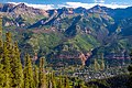 Mt. Emma upper right, Telluride below
 -
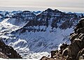 Mt. Emma to left of Gilpin Peak (viewed from Mt. Sneffels)
 -
 Mount Emma (centered) seen from golf course looking northeast


See also
 Mountains portal
 Colorado portal


- Mountains of San Miguel County, Colorado
References
- ^ a b c d "Mount Emma, Colorado". Peakbagger.com.
- ^ a b c d "Emma, Mount - 13,581' CO". listsofjohn.com. Retrieved 2021-07-01.
- ^ a b "Mount Emma". Geographic Names Information System. United States Geological Survey, United States Department of the Interior. Retrieved 2021-07-01.
- ^ Don Scarmuzzi, 2013, Telluride Trails: Hiking Passes, Loops, and Summits of Southwest Colorado, Graphic Arts Books, ISBN 9780871089977.
- ^ Peel, M. C.; Finlayson, B. L.; McMahon, T. A. (2007). "Updated world map of the Köppen−Geiger climate classification". Hydrol. Earth Syst. Sci. 11. ISSN 1027-5606.
External links
- Weather forecast: Mount Emma
- Emma Woodruff Hayden: Findagrave.com
- v
- t
- e

- Mount Garfield
- Aspen Mountain
- Capitol Peak
- Castle Peak
- Cathedral Peak
- Chair Mountain
- Crested Butte
- Gothic Mountain
- Italian Mountain
- Maroon Bells
- Mount Emmons
- Mount Owen
- Mount Sopris
- Pyramid Peak
- Snowmass Mountain
- Snowmass Peak
- Treasure Mountain
- Black Mountain (Moffat County)
- Columbus Mountain
- Elk Mountain (Routt County)
- Hahns Peak
- Flat Top Mountain
- Sleepy Cat Peak
- Eagles Nest
- Jacque Peak
- Meridian Peak
- Mount Powell
- The Spider
- Crater Peak
- North Mamm Peak
- Clark Peak
- Arkansas Hills
- Clinton Peak
- Dyer Mountain
- Gemini Peak
- Horseshoe Mountain
- Mount Arkansas
- Mount Bross
- Mount Buckskin
- Mount Democrat
- Mount Lincoln
- Mount Sheridan
- Mount Sherman
- Pacific Peak
- West Buffalo Peak
- Elk Mountain (Grand County)
- Parkview Mountain
- Radial Mountain
- Whiteley Peak
| Sangre de Cristo Range |
|
|---|---|
| Wet Mountains |
|
| Others |
|
| Collegiate Peaks |
|
|---|---|
| Others |
|
- Crystal Peak
- Fletcher Mountain
- Peak 10
- Peak One
- Quandary Peak
- Tenmile Peak
- Bear Mountain
- Blair Mountain
- Chalk Mountains
- Cochetopa Hills
- Dawson Butte
- Diamond Peak
- Flirtation Peak
- Granite Peak
- Grand Hogback
- Grannys Nipple
- Horsefly Peak
- Lead Mountain (Grand County)
- Mount Neva
- Powell Peak
- San Luis Hills
- Storm King Mountain
- Terrible Mountain
- Two Buttes
- Ute Mountain


