List of national monuments in County Kilkenny
Map all coordinates using OpenStreetMap
Download coordinates as:
- KML
- GPX (all coordinates)
- GPX (primary coordinates)
- GPX (secondary coordinates)
The Irish state has officially approved the following list of national monuments in County Kilkenny. In the Republic of Ireland, a structure or site may be deemed to be a "national monument", and therefore worthy of state protection, if it is of national importance. If the land adjoining the monument is essential to protect it, this land may also be protected.
National Monuments
| NM# | Monument name | Description | Image | Townland | Location |
|---|---|---|---|---|---|
| 334 | Aghaviller | Church & Round Tower |  | Aghaviller | 52°27′55″N 7°16′05″W / 52.465167°N 7.2679167°W / 52.465167; -7.2679167 |
| 599 | Ballyboodan Ogham Stone | Ogham Stone (AD 700-900) |  | Ballyboodan | 52°28′12″N 7°13′22″W / 52.4701036°N 7.2226583°W / 52.4701036; -7.2226583 |
| 282 | Ballylarkin Church | Church |  | Ballylarkin Upper | 52°43′22″N 7°25′39″W / 52.722866°N 7.427629°W / 52.722866; -7.427629 |
| 475 | Callan Augustinian Friary | Friary (Augustinians) |  | Callan North | 52°32′45″N 7°23′14″W / 52.545787°N 7.387348°W / 52.545787; -7.387348 |
| 455 | Callan Church (St. Mary's) | Church |  | Callan South | 52°32′39″N 7°23′25″W / 52.544064°N 7.39015°W / 52.544064; -7.39015 |
| 79 | Kilkieran High Crosses | High Crosses | 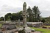 | Castletown (Iverk barony) | 52°23′52″N 7°22′51″W / 52.397809°N 7.380761°W / 52.397809; -7.380761 |
| 274 | Clara Castle | Castle |  | Clara Upper | 52°40′10″N 7°09′08″W / 52.669444°N 7.152168°W / 52.669444; -7.152168 |
| 77 | Clonamery Church | Church | Clonamery | 52°28′01″N 7°01′54″W / 52.466927°N 7.031789°W / 52.466927; -7.031789 | |
| 646 | Coolhill Castle | Donjon |  | Coolhill | 52°27′54″N 6°55′56″W / 52.464942°N 6.932191°W / 52.464942; -6.932191 |
| 321 | Burnchurch Castle | Castle & Tower |  | Farmley | 52°34′34″N 7°17′51″W / 52.576039°N 7.297509°W / 52.576039; -7.297509 |
| 522 | Magdalan Castle | Castle |  | Gardens Kilkenny City | 52°39′10″N 7°14′41″W / 52.652673°N 7.244756°W / 52.652673; -7.244756 |
| 331, 344 | St. John's Abbey, Kilkenny | Priory (Augustinian) (part of & chancel) | 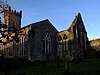 | Gardens Kilkenny City | 52°39′13″N 7°14′54″W / 52.653549°N 7.248406°W / 52.653549; -7.248406 |
| 626 | Kells Castle | Motte & Bailey |  | Garrynamann Lower Kells, County Kilkenny | 52°32′18″N 7°16′01″W / 52.538333°N 7.266944°W / 52.538333; -7.266944 |
| 214 | St. Mary's Collegiate Church Gowran | Collegiate Church | 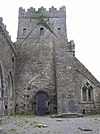 | Gowran | 52°37′45″N 7°03′48″W / 52.6292°N 7.0633°W / 52.6292; -7.0633 |
| 620 | Graiguenamanagh Abbey | Abbey (Cistercians) |  | Graiguenamanagh | 52°32′27″N 6°57′16″W / 52.54076°N 6.954525°W / 52.54076; -6.954525 |
| 74 | Grangefertagh | Round Tower & Church |  | Grangefertagh | 52°46′42″N 7°32′41″W / 52.77841°N 7.544691°W / 52.77841; -7.544691 |
| 80 | Jerpoint Abbey | Abbey (Cistercian) | 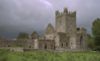 | Jerpointabbey | 52°30′39″N 7°09′28″W / 52.510713°N 7.157804°W / 52.510713; -7.157804 |
| 300 | Kilfane Church | Church | 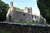 | Kilfane Demesne | 52°33′15″N 7°07′06″W / 52.554055°N 7.118406°W / 52.554055; -7.118406 |
| 75 | Killamery High Cross | High Cross |  | Killamery | 52°28′31″N 7°26′45″W / 52.475389°N 7.445971°W / 52.475389; -7.445971 |
| 324 | Kilmogue Portal Tomb | Portal Tomb |  | Kilmogue, Harristown | 52°24′11″N 7°15′45″W / 52.403077°N 7.2625°W / 52.403077; -7.2625 |
| 76 | Kilree | Church, Round Tower & Cross | 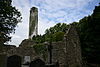 | Kilree | 52°31′05″N 7°16′07″W / 52.518108°N 7.268573°W / 52.518108; -7.268573 |
| 655 | Knockroe Passage Tomb | Passage Tomb |  | Knockroe (Kells, Killamery) | 52°25′54″N 7°23′59″W / 52.43175°N 7.39981°W / 52.43175; -7.39981 |
| 399 | Dunmore Cave | Cave |  | Ballyfoyle | 52°44′02″N 7°14′48″W / 52.733946°N 7.246579°W / 52.733946; -7.246579 |
| 180 | Kells Priory | Priory (Augustinian) | 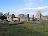 | Rathduff (Madden) | 52°32′19″N 7°16′01″W / 52.538632°N 7.266906°W / 52.538632; -7.266906 |
| 376 | Rathealy Ringfort | Ringfort | Rathealy | 52°41′41″N 7°25′57″W / 52.694722°N 7.432625°W / 52.694722; -7.432625 | |
| 73 | Sheepstown Church | Church |  | Sheepstown | 52°29′06″N 7°14′36″W / 52.485080°N 7.243442°W / 52.485080; -7.243442 |
| 72 | St. Francis Abbey (Kilkenny) | Friary (Franciscan) | 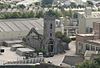 | St. Mary's Parish | 52°39′21″N 7°15′12″W / 52.655926°N 7.253431°W / 52.655926; -7.253431 |
| 191 | Thomastown Church | Church | 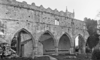 | Thomastown | 52°31′33″N 7°08′22″W / 52.525937°N 7.139316°W / 52.525937; -7.139316 |
| 161 | Tullaherin | Round Tower |  | Tullaherin | 52°34′45″N 7°07′50″W / 52.579284°N 7.130428°W / 52.579284; -7.130428 |
| 670 | Tullaroan Church | Church |  | Tullaroan | 52°39′29″N 7°26′01″W / 52.658076°N 7.43363°W / 52.658076; -7.43363 |
| 78 | Ullard Church | Church |  | Ullard | 52°34′49″N 6°55′59″W / 52.580162°N 6.932934°W / 52.580162; -6.932934 |
| 372 | Callan Motte | Motte |  | Westcourt Demesne | 52°32′48″N 7°23′29″W / 52.546749°N 7.391368°W / 52.546749; -7.391368 |
| St. Lachtain's Church, Freshford | Church |  | Freshford Lots | 52°43′58″N 7°23′52″W / 52.73269°N 7.39785°W / 52.73269; -7.39785 | |
| Shee Alms House | Almshouse |  | Gardens | 52°39′05″N 7°15′06″W / 52.65144°N 7.25155°W / 52.65144; -7.25155 | |
| Kyteler's Inn | Public house |  | Gardens | 52°39′11″N 7°15′12″W / 52.65319°N 7.25333°W / 52.65319; -7.25333 | |
| Archer Mansion | early modern townhouse | Gardens | 52°39′05″N 7°15′11″W / 52.65147°N 7.25313°W / 52.65147; -7.25313 | ||
| Rothe House | early modern townhouse |  | Gardens | 52°39′15″N 7°15′18″W / 52.65425°N 7.25487°W / 52.65425; -7.25487 |
See also
References
- "National Monuments in State Care: Ownership & Guardianship 4th March 2009 - Kilkenny" (PDF). Ireland: National Monuments Service. Retrieved 12 October 2020.
- "National Monuments in State Care: Ownership & Guardianship Kilkenny" (PDF). archaeology.ie. National Monuments Service. 2009.


