List of historic places in Kings County, Prince Edward Island

This article is a list of historic places in Kings County, Prince Edward Island entered on the Canadian Register of Historic Places, whether they are federal, provincial, or municipal.
Map all coordinates using OpenStreetMap
Download coordinates as:
- KML
- GPX (all coordinates)
- GPX (primary coordinates)
- GPX (secondary coordinates)
List of historic places
| Name | Address | Coordinates | Government recognition (CRHP №) | Image | |
|---|---|---|---|---|---|
| The A.A. Building | 577 Main Street Montague PE | 46°09′48″N 62°38′43″W / 46.1632°N 62.6453°W / 46.1632; -62.6453 (The A.A. Building) | Prince Edward Island (8994) |  Upload Photo | |
| Aitken House | 28 St. Andrews Point Road Lower Montague PE | 46°10′11″N 62°33′33″W / 46.1698°N 62.5592°W / 46.1698; -62.5592 (Aitken House) | Prince Edward Island (12019) | Upload Photo | |
| All Saints Roman Catholic Church | 4279 Chapel Road - Route 321 Cardigan PE | 46°14′33″N 62°37′20″W / 46.2425°N 62.6221°W / 46.2425; -62.6221 (All Saints Roman Catholic Church) | Prince Edward Island (11344) | Upload Photo | |
| Annandale Rear Range Lighthouse | Lighthouse Road Annandale PE | 46°16′00″N 62°26′17″W / 46.2668°N 62.4380°W / 46.2668; -62.4380 (Annandale Rear Range Lighthouse) | Prince Edward Island (22597) |  | |
| Beck's Furniture and Appliances | 18 Water Street Montague PE | 46°09′52″N 62°38′44″W / 46.1644°N 62.6456°W / 46.1644; -62.6456 (Beck's Furniture and Appliances) | Prince Edward Island (9051) | Upload Photo | |
| Edward Blaisdell Home | 591 Main Street Montague PE | 46°09′47″N 62°38′37″W / 46.163°N 62.6437°W / 46.163; -62.6437 (Edward Blaisdell Home) | Prince Edward Island (9055) | Upload Photo | |
| Blanchard Cottage | 35 Burkes Lane Fortune PE | 46°20′00″N 62°20′46″W / 46.3334°N 62.3462°W / 46.3334; -62.3462 (Blanchard Cottage) | Prince Edward Island (15126) | Upload Photo | |
| Brehaut-Beck House | 3611 Cape Bear Road - Route 18 Guernsey Cove PE | 45°58′33″N 62°31′13″W / 45.9758°N 62.5203°W / 45.9758; -62.5203 (Brehaut-Beck House) | Prince Edward Island (15901) | Upload Photo | |
| John and Jocelyn Brothers Home | 341 Shore Road Cardigan PE | 46°13′51″N 62°37′18″W / 46.2309°N 62.6216°W / 46.2309; -62.6216 (John and Jocelyn Brothers Home) | Prince Edward Island (10745) | Upload Photo | |
| Bruce Road Pioneer Grave | Bruce Road - Route 349 Glenwilliam PE | 46°02′40″N 62°38′52″W / 46.0445°N 62.6477°W / 46.0445; -62.6477 (Bruce Road Pioneer Grave) | Prince Edward Island (16061) | Upload Photo | |
| Brudenell Community Centre | 415 Brudenell Point Road - Route 319 Brudenell PE | 46°11′28″N 62°37′46″W / 46.1912°N 62.6294°W / 46.1912; -62.6294 (Brudenell Community Centre) | Prince Edward Island (12098) | Upload Photo | |
| Brudenell Island Pioneer Cemetery | Brudenell Island Georgetown Royalty PE | 46°11′48″N 62°34′45″W / 46.1966°N 62.5793°W / 46.1966; -62.5793 (Brudenell Island Pioneer Cemetery) | Prince Edward Island (11659) | Upload Photo | |
| John Burck House | 580 Main Street Montague PE | 46°09′49″N 62°38′42″W / 46.1635°N 62.645°W / 46.1635; -62.645 (John Burck House) | Prince Edward Island (8863) | Upload Photo | |
| Caledonia Presbyterian Church | 2064 Murray Harbour Road, Rte. 24 Caledonia PE | 46°03′41″N 62°42′41″W / 46.0613°N 62.7114°W / 46.0613; -62.7114 (Caledonia Presbyterian Church) | Prince Edward Island (18704) | Upload Photo | |
| Anna Campbell Home | 5692 Sparrows Road, Route 320 Victoria Cross PE | 46°09′35″N 62°40′37″W / 46.1597°N 62.6769°W / 46.1597; -62.6769 (Anna Campbell Home) | Prince Edward Island (10742) | Upload Photo | |
| The Cannery at Basin Head Fisheries Museum | 336 Basin Head Road Basin Head PE | 46°22′43″N 62°06′33″W / 46.3786°N 62.1091°W / 46.3786; -62.1091 (The Cannery at Basin Head Fisheries Museum) | Prince Edward Island (7436) | Upload Photo | |
| Cape Bear Lighthouse | 42 Black Brook Road Beach Point PE | 46°00′13″N 62°27′28″W / 46.0036°N 62.4579°W / 46.0036; -62.4579 (Cape Bear Lighthouse) | Federal (11034, (21134), Prince Edward Island (19728) |  | |
| Cardigan Craft Centre | 358 Shore Road Cardigan PE | 46°13′50″N 62°37′14″W / 46.2306°N 62.6206°W / 46.2306; -62.6206 (Cardigan Craft Centre) | Prince Edward Island (10731) | Upload Photo | |
| Chester's Barber Shop and Laurie's Beauty Salon | 571 Main Street Montague PE | 46°09′48″N 62°38′46″W / 46.1634°N 62.6462°W / 46.1634; -62.6462 (Chester's Barber Shop and Laurie's Beauty Salon) | Prince Edward Island (9151) | Upload Photo | |
| Church of Christ | 513 Main Street Montague PE | 46°10′16″N 62°39′05″W / 46.1712°N 62.6514°W / 46.1712; -62.6514 (Church of Christ) | Prince Edward Island (8841) | Upload Photo | |
| Clow House | 27 Mink River Road Murray Harbour North PE | 46°02′59″N 62°31′13″W / 46.0498°N 62.5202°W / 46.0498; -62.5202 (Clow House) | Prince Edward Island (19409) | Upload Photo | |
| Edgar and Brenda Dewar Home | 135 Dewars Road Roseneath PE | 46°12′04″N 62°38′52″W / 46.2011°N 62.6479°W / 46.2011; -62.6479 (Edgar and Brenda Dewar Home) | Prince Edward Island (11973) | Upload Photo | |
| Gordon Douglas House | 13 Water Street Georgetown PE | 46°10′48″N 62°32′13″W / 46.1801°N 62.5369°W / 46.1801; -62.5369 (Gordon Douglas House) | Prince Edward Island (11514) | Upload Photo | |
| East Point Fog Alarm Building | East Point PE | 46°27′08″N 61°58′18″W / 46.4523°N 61.9717°W / 46.4523; -61.9717 (East Point Fog Alarm Building) | Prince Edward Island (19205) |  | |
| Mary Elliot Home | 11 Sunset Lane Lower Montague PE | 46°10′08″N 62°33′46″W / 46.169°N 62.5629°W / 46.169; -62.5629 (Mary Elliot Home) | Prince Edward Island (10729) | Upload Photo | |
| Elmira Railway Station | 457 Elmira Road, Route 16A Elmira PE | 46°26′24″N 62°03′52″W / 46.4399°N 62.0645°W / 46.4399; -62.0645 (Elmira Railway Station) | Prince Edward Island (4604) |  | |
| English Church Cemetery | Murray Harbour Road - Route 18 Murray Harbour South PE | 46°00′14″N 62°31′14″W / 46.0038°N 62.5205°W / 46.0038; -62.5205 (English Church Cemetery) | Prince Edward Island (12844) | Upload Photo | |
| Former Murray River United Church | 9328 Main Street North Murray River PE | 46°00′59″N 62°36′54″W / 46.0165°N 62.615°W / 46.0165; -62.615 (Former Murray River United Church) | Prince Edward Island (16441) | Upload Photo | |
| Garden of the Gulf Museum | 564 Main Street Montague PE | 46°09′50″N 62°38′50″W / 46.1638°N 62.6471°W / 46.1638; -62.6471 (Garden of the Gulf Museum) | Prince Edward Island (9318) | 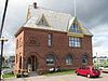 | |
| Karen and Ron Garrett Home | 13 Parkman Avenue Montague PE | 46°09′45″N 62°38′51″W / 46.1624°N 62.6475°W / 46.1624; -62.6475 (Karen and Ron Garrett Home) | Prince Edward Island (11503) | Upload Photo | |
| Georgetown Inn | 62 Richmond Street Georgetown PE | 46°10′53″N 62°31′59″W / 46.1815°N 62.533°W / 46.1815; -62.533 (Georgetown Inn) | Prince Edward Island (1662) | Upload Photo | |
| The Goff House | 5127 Launching Road, Route 311 Woodville Mills PE | 46°14′25″N 62°31′02″W / 46.2402°N 62.5173°W / 46.2402; -62.5173 (The Goff House) | Prince Edward Island (5307) | Upload Photo | |
| Government of Canada Building, Montague | 551 Main Street North Montague PE | 46°09′56″N 62°38′57″W / 46.1656°N 62.6491°W / 46.1656; -62.6491 (Government of Canada Building, Montague) | Federal (11085), Prince Edward Island (19432) | Upload Photo | |
| The Graphic Office | 567 Main Street Montague PE | 46°09′49″N 62°38′50″W / 46.1635°N 62.6471°W / 46.1635; -62.6471 (The Graphic Office) | Prince Edward Island (8910) | Upload Photo | |
| Francis Hebert Machine Shop | 45 Victoria Street Georgetown PE | 46°11′02″N 62°31′50″W / 46.184°N 62.5306°W / 46.184; -62.5306 (Francis Hebert Machine Shop) | Prince Edward Island (11328) | Upload Photo | |
| Holy Trinity Anglican Church | 93 Grafton Street Georgetown PE | 46°10′59″N 62°31′49″W / 46.1830°N 62.5303°W / 46.1830; -62.5303 (Holy Trinity Anglican Church) | Prince Edward Island (12046) |  | |
| Dan and Janet Hughes Home | 615 Main Street Montague PE | 46°09′44″N 62°38′25″W / 46.1622°N 62.6402°W / 46.1622; -62.6402 (Dan and Janet Hughes Home) | Prince Edward Island (8958) | Upload Photo | |
| The Hyndman Building | 543 Main Street Montague PE | 46°09′58″N 62°38′58″W / 46.1662°N 62.6495°W / 46.1662; -62.6495 (The Hyndman Building) | Prince Edward Island (8978) | Upload Photo | |
| The Jackson House | 601 Main Street Montague PE | 46°09′46″N 62°38′34″W / 46.1629°N 62.6427°W / 46.1629; -62.6427 (The Jackson House) | Prince Edward Island (9662) | Upload Photo | |
| Kings County Courthouse | 60 Kent Street Georgetown PE | 46°11′03″N 62°32′00″W / 46.1841°N 62.5333°W / 46.1841; -62.5333 (Kings County Courthouse) | Prince Edward Island (7442) |  | |
| Knox's Dam | Route 320 Victoria Cross PE | 46°09′31″N 62°40′31″W / 46.1587°N 62.6753°W / 46.1587; -62.6753 (Knox's Dam) | Prince Edward Island (12038) | Upload Photo | |
| Knox's Dam Bed and Breakfast | 442 South Montague Road - Route 353 Victoria Cross PE | 46°09′31″N 62°40′27″W / 46.1585°N 62.6743°W / 46.1585; -62.6743 (Knox's Dam Bed and Breakfast) | Prince Edward Island (12025) |  | |
| Launching 1790 Pioneer Cemetery | St. Michael's Lane Launching PE | 46°12′49″N 62°24′44″W / 46.2136°N 62.4122°W / 46.2136; -62.4122 (Launching 1790 Pioneer Cemetery) | Prince Edward Island (16021) | Upload Photo | |
| Launching Pioneer Cemetery | Primrose Road - Route 311 Launching PE | 46°13′15″N 62°25′52″W / 46.2209°N 62.4312°W / 46.2209; -62.4312 (Launching Pioneer Cemetery) | Prince Edward Island (12261) | Upload Photo | |
| Lewis and Clara Ann Lavandier House | 86 Grafton Street Georgetown PE | 46°10′58″N 62°31′52″W / 46.1828°N 62.531°W / 46.1828; -62.531 (Lewis and Clara Ann Lavandier House) | Prince Edward Island (11401) | Upload Photo | |
| Fred W. LeLacheur House | 210 Route 18A Murray Harbour PE | 45°59′39″N 62°31′42″W / 45.9943°N 62.5283°W / 45.9943; -62.5283 (Fred W. LeLacheur House) | Prince Edward Island (15906) | Upload Photo | |
| Lime Kiln - Zita Boudreault Property | 651 Route 17 Lower Montague PE | 46°10′24″N 62°36′24″W / 46.1732°N 62.6068°W / 46.1732; -62.6068 (Lime Kiln - Zita Boudreault Property) | Prince Edward Island (11369) | Upload Photo | |
| Lime Kiln - Former Campbell Property | 494 Route 17 Lower Montague PE | 46°09′52″N 62°36′53″W / 46.1644°N 62.6148°W / 46.1644; -62.6148 (Lime Kiln - Former Campbell Property) | Prince Edward Island (15921) | Upload Photo | |
| Little Sands United Church | 11352 Shore Road, Route 4 Little Sands PE | 45°57′58″N 62°38′45″W / 45.9662°N 62.6457°W / 45.9662; -62.6457 (Little Sands United Church) | Prince Edward Island (5255) | Upload Photo | |
| Lubbert and Beaulieu Home | 608 Main Street Montague PE | 46°09′47″N 62°38′30″W / 46.163°N 62.6416°W / 46.163; -62.6416 (Lubbert and Beaulieu Home) | Prince Edward Island (9136) | Upload Photo | |
| The Mabon House | 600 Main Street Montague PE | 46°09′47″N 62°38′33″W / 46.1631°N 62.6425°W / 46.1631; -62.6425 (The Mabon House) | Prince Edward Island (8937) | Upload Photo | |
| Peter MacCallum House | 89 Bay Shore Road St. Peter's Bay PE | 46°25′08″N 62°35′01″W / 46.419°N 62.5836°W / 46.419; -62.5836 (Peter MacCallum House) | Prince Edward Island (1944) | Upload Photo | |
| MacDonald House | 65 Water Street Georgetown PE | 46°10′51″N 62°31′55″W / 46.1809°N 62.5319°W / 46.1809; -62.5319 (MacDonald House) | Prince Edward Island (11441) | Upload Photo | |
| Dr. Gus MacDonald House | 8 Church Avenue Souris PE | 46°21′17″N 62°15′16″W / 46.3546°N 62.2545°W / 46.3546; -62.2545 (Dr. Gus MacDonald House) | Prince Edward Island (19661) | Upload Photo | |
| Joe and Nora MacDonald Home | 64 Pleasant Street Cardigan PE | 46°14′02″N 62°37′03″W / 46.2339°N 62.6174°W / 46.2339; -62.6174 (Joe and Nora MacDonald Home) | Prince Edward Island (11554) | Upload Photo | |
| John A. MacDonald Store | 4557 Wharf Road Cardigan PE | 46°13′51″N 62°37′07″W / 46.2307°N 62.6185°W / 46.2307; -62.6185 (John A. MacDonald Store) | Prince Edward Island (19169) | Upload Photo | |
| Dr. Roddie MacDonald House | 5707 St. Peters Road, Rte. 2 St. Peters Bay PE | 46°24′53″N 62°35′07″W / 46.4146°N 62.5854°W / 46.4146; -62.5854 (Dr. Roddie MacDonald House) | Prince Edward Island (20485) | Upload Photo | |
| MacEachern Barn | 7737 Northside Road Priests Pond PE | 46°28′33″N 62°09′09″W / 46.4757°N 62.1525°W / 46.4757; -62.1525 (MacEachern Barn) | Prince Edward Island (19744) | Upload Photo | |
| MacKay Pioneer Cemetery | Cemetery Road Murray Harbour PE | 46°00′22″N 62°30′48″W / 46.006°N 62.5134°W / 46.006; -62.5134 (MacKay Pioneer Cemetery) | Prince Edward Island (16043) | Upload Photo | |
| The MacLaren Building | 514 Main Street Montague PE | 46°10′11″N 62°39′02″W / 46.1697°N 62.6505°W / 46.1697; -62.6505 (The MacLaren Building) | Prince Edward Island (9059) | Upload Photo | |
| Shirley MacNeill Home | 117 Chestnut Street Montague PE | 46°09′46″N 62°38′46″W / 46.1627°N 62.646°W / 46.1627; -62.646 (Shirley MacNeill Home) | Prince Edward Island (8893) | Upload Photo | |
| Charles and Vicky Mahar Home | 126 Grafton Street Georgetown PE | 46°11′01″N 62°31′39″W / 46.1835°N 62.5274°W / 46.1835; -62.5274 (Charles and Vicky Mahar Home) | Prince Edward Island (10703) | Upload Photo | |
| Therese Mair House | 20 Kent Street Georgetown PE | 46°10′54″N 62°31′56″W / 46.1816°N 62.5322°W / 46.1816; -62.5322 (Therese Mair House) | Prince Edward Island (11204) | Upload Photo | |
| Timothy Mair House | 12 Kent Street Georgetown PE | 46°10′51″N 62°31′55″W / 46.1808°N 62.5319°W / 46.1808; -62.5319 (Timothy Mair House) | Prince Edward Island (12071) | Upload Photo | |
| Archibald Matheson House | 142 Albion Road, Route 327 Albion Cross PE | 46°19′42″N 62°29′03″W / 46.3283°N 62.4841°W / 46.3283; -62.4841 (Archibald Matheson House) | Prince Edward Island (1661) | Upload Photo | |
| Matthew House | 15 Breakwater Street Souris PE | 46°21′10″N 62°15′05″W / 46.3527°N 62.2513°W / 46.3527; -62.2513 (Matthew House) | Prince Edward Island (19170) | Upload Photo | |
| Matthew and McLean Heritage Building | 95 Main Street Souris PE | 46°21′17″N 62°15′12″W / 46.3547°N 62.2534°W / 46.3547; -62.2534 (Matthew and McLean Heritage Building) | Prince Edward Island (5983) | Upload Photo | |
| McLean House Inn | 16 Washington Street Souris PE | 46°21′13″N 62°15′13″W / 46.3535°N 62.2537°W / 46.3535; -62.2537 (McLean House Inn) | Prince Edward Island (18476) | Upload Photo | |
| McNichol-Best House | 57 Owens Wharf Road Cardigan PE | 46°13′50″N 62°36′54″W / 46.2306°N 62.6150°W / 46.2306; -62.6150 (McNichol-Best House) | Prince Edward Island (20525) | Upload Photo | |
| Harvey Moore Wildlife Centre | 7096 Commercial Road - Route 4 Milltown Cross PE | 46°06′42″N 62°37′34″W / 46.1118°N 62.626°W / 46.1118; -62.626 (Harvey Moore Wildlife Centre) | Prince Edward Island (12361) | Upload Photo | |
| David and Catherine Morrison Home | 610 Main Street Montague PE | 46°09′46″N 62°38′29″W / 46.1629°N 62.6414°W / 46.1629; -62.6414 (David and Catherine Morrison Home) | Prince Edward Island (9103) | Upload Photo | |
| Duncan Munn Property | 11533 Shore Road - Route 4 Little Sands PE | 45°57′55″N 62°39′26″W / 45.9652°N 62.6573°W / 45.9652; -62.6573 (Duncan Munn Property) | Prince Edward Island (15817) | Upload Photo | |
| The Munroe House | 41 Riverside Drive Montague PE | 46°09′46″N 62°39′15″W / 46.1629°N 62.6542°W / 46.1629; -62.6542 (The Munroe House) | Prince Edward Island (9160) | Upload Photo | |
| Kenneth A. Murphy House | 892 Route 17 Lower Montague PE | 46°09′49″N 62°35′28″W / 46.1636°N 62.5912°W / 46.1636; -62.5912 (Kenneth A. Murphy House) | Prince Edward Island (11297) | Upload Photo | |
| Murray River Pioneer Cemetery | Pioneer Cemetery Road Murray River PE | 46°00′37″N 62°35′32″W / 46.0102°N 62.5921°W / 46.0102; -62.5921 (Murray River Pioneer Cemetery) | Prince Edward Island (12834) | Upload Photo | |
| Kent and Lyda Myers Home | 2654 Route 3 New Perth PE | 46°12′41″N 62°40′36″W / 46.2113°N 62.6767°W / 46.2113; -62.6767 (Kent and Lyda Myers Home) | Prince Edward Island (12072) | Upload Photo | |
| Manfred and Christian Ohlandt Property | 58-62 Grafton Street Georgetown PE | 46°10′56″N 62°32′00″W / 46.1823°N 62.5334°W / 46.1823; -62.5334 (Manfred and Christian Ohlandt Property) | Prince Edward Island (11284) | Upload Photo | |
| Panmure Island Lighthouse | Lighthouse Road Montague PE | 46°08′41″N 62°28′03″W / 46.1446°N 62.4676°W / 46.1446; -62.4676 (Panmure Island Lighthouse) | Federal (20731), Prince Edward Island (19723) | 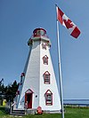 | |
| Panmure Island Pioneer Cemetery | Lot 61 Panmure Island PE | 46°08′17″N 62°30′07″W / 46.138°N 62.502°W / 46.138; -62.502 (Panmure Island Pioneer Cemetery) | Prince Edward Island (12205) | Upload Photo | |
| Doug and Maureen Panting Home | 625 Main Street Montague PE | 46°09′43″N 62°38′14″W / 46.1619°N 62.6373°W / 46.1619; -62.6373 (Doug and Maureen Panting Home) | Prince Edward Island (9697) | Upload Photo | |
| Terry Parker Home | 13 Richmond Street Georgetown PE | 46°10′51″N 62°32′14″W / 46.1809°N 62.5372°W / 46.1809; -62.5372 (Terry Parker Home) | Prince Edward Island (10732) | Upload Photo | |
| Perreault / Parent House | 598 Main Street Montague PE | 46°09′48″N 62°38′34″W / 46.1633°N 62.6428°W / 46.1633; -62.6428 (Perreault / Parent House) | Prince Edward Island (10736) | Upload Photo | |
| The Pine's Bed and Breakfast | 31 Riverside Drive Montague PE | 46°09′49″N 62°39′08″W / 46.1635°N 62.6522°W / 46.1635; -62.6522 (The Pine's Bed and Breakfast) | Prince Edward Island (9092) | Upload Photo | |
| George Poole Home | 430 Lower Montague Road Lower Montague PE | 46°10′11″N 62°33′43″W / 46.1696°N 62.562°W / 46.1696; -62.562 (George Poole Home) | Prince Edward Island (10725) | Upload Photo | |
| Kenny and Annette Power House | 612 Main Street Montague PE | 46°09′46″N 62°38′27″W / 46.1628°N 62.6407°W / 46.1628; -62.6407 (Kenny and Annette Power House) | Prince Edward Island (9665) | Upload Photo | |
| Samuel Prowse House | 1278 Main Street Murray Harbour PE | 46°00′20″N 62°31′29″W / 46.0055°N 62.5246°W / 46.0055; -62.5246 (Samuel Prowse House) | Prince Edward Island (15809) | Upload Photo | |
| Red Bank Pioneer Cemetery | 195 North Lake Harbour Road North Lake PE | 46°28′00″N 62°04′22″W / 46.4666°N 62.0728°W / 46.4666; -62.0728 (Red Bank Pioneer Cemetery) | Prince Edward Island (16006) | Upload Photo | |
| Silas Sewell Robertson Farm House | 2937 East Point Road - Route 16 Kingsboro PE | 46°23′53″N 62°05′37″W / 46.398°N 62.0935°W / 46.398; -62.0935 (Silas Sewell Robertson Farm House) | Prince Edward Island (9288) | Upload Photo | |
| Jean-Pierre Roma at Three Rivers National Historic Site of Canada | Brudenell PE | 46°10′54″N 62°33′36″W / 46.1818°N 62.5601°W / 46.1818; -62.5601 (Jean-Pierre Roma at Three Rivers National Historic Site of Canada) | Federal (8459) | Upload Photo | |
| Alvin Roy House | 619 Main Street Montague PE | 46°09′44″N 62°38′21″W / 46.1623°N 62.6392°W / 46.1623; -62.6392 (Alvin Roy House) | Prince Edward Island (9669) | Upload Photo | |
| St. Alexis Mission | Cemetery Road Rollo Bay East PE | 46°21′06″N 62°19′04″W / 46.3517°N 62.3178°W / 46.3517; -62.3178 (St. Alexis Mission) | Prince Edward Island (1884) | Upload Photo | |
| St. Andrew's Point Pioneer Cemetery | St. Andrew's Point Road Lower Montague PE | 46°09′32″N 62°31′37″W / 46.1589°N 62.527°W / 46.1589; -62.527 (St. Andrew's Point Pioneer Cemetery) | Prince Edward Island (11600) | Upload Photo | |
| St. Andrew's Presbyterian Church | 268 Shore Road Cardigan PE | 46°13′57″N 62°37′30″W / 46.2325°N 62.6251°W / 46.2325; -62.6251 (St. Andrew's Presbyterian Church) | Prince Edward Island (10722) | Upload Photo | |
| St. David's United Church | 50 Grafton Street Georgetown PE | 46°10′56″N 62°32′03″W / 46.1821°N 62.5341°W / 46.1821; -62.5341 (St. David's United Church) | Prince Edward Island (11965) | Upload Photo | |
| St. Margaret of Scotland Pioneer Cemetery | Bear Shore Road St. Margarets PE | 46°28′01″N 62°23′02″W / 46.467°N 62.384°W / 46.467; -62.384 (St. Margaret of Scotland Pioneer Cemetery) | Prince Edward Island (13172) | Upload Photo | |
| St. Mary's Roman Catholic Church | 1 Longworth Street Souris PE | 46°21′34″N 62°15′11″W / 46.3595°N 62.2531°W / 46.3595; -62.2531 (St. Mary's Roman Catholic Church) | Prince Edward Island (19171) |  | |
| St. Paul's Roman Catholic Church | 1133 Cambridge Road - Route 17A Sturgeon PE | 46°06′26″N 62°32′01″W / 46.1072°N 62.5336°W / 46.1072; -62.5336 (St. Paul's Roman Catholic Church) | Prince Edward Island (11275) | Upload Photo | |
| St. Peter's Bay United Church | 5781 St. Peter's Road - Route 2 St. Peter's Bay PE | 46°24′50″N 62°35′25″W / 46.4139°N 62.5902°W / 46.4139; -62.5902 (St. Peter's Bay United Church) | Prince Edward Island (9666) | Upload Photo | |
| St. Peter's Courthouse | 5697 St. Peters Road, Rte 2 St. Peter's Bay PE | 46°24′53″N 62°35′05″W / 46.4146°N 62.5847°W / 46.4146; -62.5847 (St. Peter's Courthouse) | Prince Edward Island (20877) | Upload Photo | |
| St. Peters Harbour Lighthouse | Lighthouse Road St. Peter's Harbour PE | 46°26′33″N 62°44′51″W / 46.4425°N 62.7476°W / 46.4425; -62.7476 (St. Peters Harbour Lighthouse) | Federal (21013) |  | |
| Sir Isaac's Restaurant and Mister Gabe's Pub | 576 Main Street Montague PE | 46°09′49″N 62°38′44″W / 46.1635°N 62.6455°W / 46.1635; -62.6455 (Sir Isaac's Restaurant and Mister Gabe's Pub) | Prince Edward Island (8877) | Upload Photo | |
| Ruby Smith Home | 2965 Route 3 New Perth PE | 46°12′42″N 62°41′48″W / 46.2118°N 62.6968°W / 46.2118; -62.6968 (Ruby Smith Home) | Prince Edward Island (12092) | Upload Photo | |
| Trent Sorrey House | 599 Main Street Montague PE | 46°09′46″N 62°38′34″W / 46.1629°N 62.6429°W / 46.1629; -62.6429 (Trent Sorrey House) | Prince Edward Island (9146) | Upload Photo | |
| Souris Historic Lighthouse | 134 Breakwater Street Souris PE | 46°20′47″N 62°14′47″W / 46.3463°N 62.2465°W / 46.3463; -62.2465 (Souris Historic Lighthouse) | Federal (10646), Prince Edward Island (18696) | 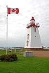 | |
| Souris Town Hall | 75 Main Street Souris PE | 46°21′18″N 62°15′18″W / 46.355°N 62.2551°W / 46.355; -62.2551 (Souris Town Hall) | Prince Edward Island (18705) | Upload Photo | |
| The Station | 1 Station Street Montague PE | 46°09′53″N 62°38′54″W / 46.1646°N 62.6482°W / 46.1646; -62.6482 (The Station) | Prince Edward Island (9374) | Upload Photo | |
| Donald B. Taylor and Arlene Smith Home | 73 Water Street Georgetown PE | 46°10′52″N 62°31′53″W / 46.1812°N 62.5314°W / 46.1812; -62.5314 (Donald B. Taylor and Arlene Smith Home) | Prince Edward Island (11492) | Upload Photo | |
| Tír na nÓg Inn | 5749 St. Peters Road St. Peter's Bay PE | 46°24′51″N 62°35′18″W / 46.4142°N 62.5883°W / 46.4142; -62.5883 (Tír na nÓg Inn) | Prince Edward Island (6275) | Upload Photo | |
| Tower East Point Light Station | East Point PE | 46°27′10″N 61°58′16″W / 46.4529°N 61.9711°W / 46.4529; -61.9711 (Tower East Point Light Station) | Federal (11479), Prince Edward Island (19729) |  | |
| Underhay House | 1610 Route 310 Eglington PE | 46°18′35″N 62°22′43″W / 46.3096°N 62.3787°W / 46.3096; -62.3787 (Underhay House) | Prince Edward Island (19147) | Upload Photo | |
| Marc and Janice Vandaele, Maple Lane B&B | 1540 Whim Road - Route 316 Commercial Cross PE | 46°07′30″N 62°38′41″W / 46.1249°N 62.6446°W / 46.1249; -62.6446 (Marc and Janice Vandaele, Maple Lane B&B) | Prince Edward Island (11520) | Upload Photo | |
| Elizabeth Watson Home | 20 Wood Islands Road Montague PE | 46°09′42″N 62°38′41″W / 46.1618°N 62.6447°W / 46.1618; -62.6447 (Elizabeth Watson Home) | Prince Edward Island (8853) | Upload Photo | |
| Joan Watson and Jackie Lavers Home | 614 Main Street Montague PE | 46°09′46″N 62°38′25″W / 46.1629°N 62.6404°W / 46.1629; -62.6404 (Joan Watson and Jackie Lavers Home) | Prince Edward Island (9375) | Upload Photo | |
| Windows on the Water Restaurant | 558 Main Street Montague PE | 46°09′54″N 62°38′55″W / 46.1649°N 62.6487°W / 46.1649; -62.6487 (Windows on the Water Restaurant) | Prince Edward Island (8949) | Upload Photo | |
| Yeo House | 569 Main Street Montague PE | 46°09′48″N 62°38′44″W / 46.1634°N 62.6456°W / 46.1634; -62.6456 (Yeo House) | Prince Edward Island (9373) | Upload Photo |
See also
- List of historic places in Prince Edward Island
- List of National Historic Sites of Canada in Prince Edward Island
- Heritage Places Protection Act
- v
- t
- e
- CRHP
- Charlottetown
- Kings County
- Prince County
- Queens County
- Summerside
- Pitaweikek (proposed)
- Prince Edward Island
- Alberton Court House
- All Souls' Chapel
- Apothecaries Hall
- Ardgowan
- Charlottetown City Hall
- Confederation Centre of the Arts
- Dalvay-by-the-Sea
- Dundas Terrace
- Fairholm
- Farmers' Bank of Rustico
- Former Summerside Post Office
- Government House
- Great George Street Historic District
- Jean-Pierre Roma at Three Rivers
- Kensington Railway Station
- L.M. Montgomery's Cavendish
- Province House
- Shaw's Hotel
- Skmaqn–Port-la-Joye–Fort Amherst
- St. Dunstan's Roman Catholic Basilica
- Strathgartney Homestead
- Tryon United Church
 Category
 Commons


