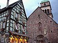
Kaysersberg
Part of Kaysersberg Vignoble in Grand Est, France
Delegated commune of Kaysersberg Vignoble in Grand Est, France
Kaysersberg Kaiserschbarig (Alsatian) Kaisersberg (German) | |
|---|---|
Delegated commune of Kaysersberg Vignoble | |
 The town as seen from the castle | |
 Coat of arms | |
Location of Kaysersberg  | |
48°08′N 7°16′E / 48.14°N 7.26°E / 48.14; 7.26 | |
| Country | France |
| Region | Grand Est |
| Department | Haut-Rhin |
| Arrondissement | Colmar-Ribeauvillé |
| Canton | Sainte-Marie-aux-Mines |
| Commune | Kaysersberg Vignoble |
| Area 1 | 24.82 km2 (9.58 sq mi) |
| Population (2019)[1] | 2,426 |
| • Density | 98/km2 (250/sq mi) |
| Time zone | UTC+01:00 (CET) |
| • Summer (DST) | UTC+02:00 (CEST) |
| Postal code | 68240 |
| Elevation | 236–924 m (774–3,031 ft) (avg. 240 m or 790 ft) |
| 1 French Land Register data, which excludes lakes, ponds, glaciers > 1 km2 (0.386 sq mi or 247 acres) and river estuaries. | |
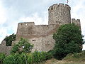
Kaysersberg (French pronunciation: [kaizəʁsbɛʁɡ]; German: Kaisersberg [ˈkaɪzɐsbɛʁk] ⓘ; Alsatian: Kaiserschbarig) is a historical town and former commune in Alsace in northeastern France. The name is German for Emperor's Mountain. The high fortress that dominates the town serves as a reminder of both its strategic importance and its warlike past.
Kaysersberg lies in the canton of Sainte-Marie-aux-Mines, which itself is a subdivision of the Colmar-Ribeauvillé arrondissement. It was a separate commune until 1 January 2016, when it was merged into the new commune of Kaysersberg Vignoble together with nearby Kientzheim and Sigolsheim, and remains its seat.[2]
The town was first mentioned in 1227, when Frederick II, Holy Roman Emperor purchased the castle and gave orders to refortify it. During the Middle Ages, Kaysersberg, a member of the Décapole, prospered. In 1648, the city became a part of France, although most inhabitants continued to speak German. From 1871 to 1918 and (again from 1940 to 1944) Kaysersberg belonged to Germany.
In 2017 Kaysersberg was voted the Village préféré des Français (Village favoured by the French). The inhabitants are called Kaysersbergeois.
Geography
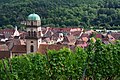
Kaysersberg lies about 12 kilometres (7 mi) northwest of Colmar, on the eastern slopes of the Vosges mountains, on the river Weiss.
Kaysersberg lies on the Route des Vins d'Alsace (Alsace "Wine Route"). Kaysersberg is north of Ammerschwihr and south of Riquewihr.
Population
| Year | Pop. | ±% p.a. |
|---|---|---|
| 1962 | 2,821 | — |
| 1968 | 2,979 | +0.91% |
| 1975 | 2,942 | −0.18% |
| 1982 | 2,707 | −1.18% |
| 1990 | 2,755 | +0.22% |
| 1999 | 2,676 | −0.32% |
| 2007 | 2,720 | +0.20% |
| 2012 | 2,705 | −0.11% |
| 2019 | 2,426 | −1.54% |
| Source: EHESS[3] and INSEE (2007-2019)[4][1] | ||
Economy
The area around Kaysersberg is one of the finest wine-growing areas in Alsace. The first vines were brought here in the 16th century from Hungary, and wine production is still an important aspect of the town's economy today. Wine produced from the pinot gris variety is a local specialty.
Culture
Kaysersberg is a historic town, that has preserved many architectural monuments. These include:
- Église Sainte-Croix, the oldest parts of which date form the 13th century[5]
- Hôtel de ville (town hall), 16th century, renaissance style[6]
- Oberhof chapel, 14th century[7]
- Saint-Michel chapel, 16th century[8]
- Château de Kaysersberg or Schlossberg, 13th century, partly ruined[9]
Tourism
Besides the fact that Alsace wine is produced locally, there is the ruin of Kaysersberg Castle. The ruins of Château de Wineck in Katzenthal, Château de Lupfen-Schwendi and Château de Reichenstein in Kientzheim are within walking distance.
Notable people
- Matthäus Zell (1477–1548), Protestant reformer
- Albert Schweitzer (1875–1965), theologian, musician, philosopher, and physician
- Anthony Bourdain (1956–2018), chef and writer, was found dead in Kaysersberg
Gallery
-
 On the left, Oberhof chapel
 -
 View of Kaysersberg
 -
 The medieval church
 -
 Fountain and facade of Holy Cross Church
 -
 1518 altar inside the medieval church
 -
 Kaysersberg's Renaissance town hall
 -
 Albert Schweitzer museum
 -
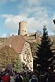 Kaysersberg is dominated by the ruins of its castle
 -
-
 Cemetery and vineyards
 -
 Bell tower and roofs seen from Schlossberg
 -
 Maison Herzer
 -
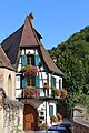 A typical building


See also
References
- ^ a b Téléchargement du fichier d'ensemble des populations légales en 2019, INSEE
- ^ Arrêté 14 July 2015 (in French)
- ^ Des villages de Cassini aux communes d'aujourd'hui: Commune data sheet Kaysersberg, EHESS (in French).
- ^ "Populations légales 2012: Commune de Kaysersberg (68162)". INSEE. 27 December 2014.
- ^ Base Mérimée: Église paroissiale Sainte-Marie puis de l'Invention-de-la-Sainte-Croix, Ministère français de la Culture. (in French)
- ^ Base Mérimée: Hôtel de ville, Ministère français de la Culture. (in French)
- ^ Base Mérimée: Chapelle de l'Oberhof dite Notre-Dame du Scapulaire, Ministère français de la Culture. (in French)
- ^ Base Mérimée: Chapelle Saint-Michel et son ossuaire (chapelle inférieure), Ministère français de la Culture. (in French)
- ^ Base Mérimée: Château dit Schlossberg et enceinte, Ministère français de la Culture. (in French)
External links
Wikimedia Commons has media related to Kaysersberg.
- Historical commune of Kaysersberg (in French)
- v
- t
- e


Category:Alsace
Authority control databases | |
|---|---|
| International |
|
| National |
|
| Geographic |
|


