Jablanica Dam
Dam in Jablanica, Herzegovina-Neretva Canton
43°41′32.79″N 17°43′57.05″E / 43.6924417°N 17.7325139°E / 43.6924417; 17.7325139
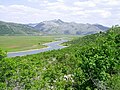
The Jablanica Dam is an arch-gravity dam on the Neretva River about 4 km (2.5 mi) northwest of Jablanica in the Herzegovina-Neretva Canton of Bosnia and Herzegovina. The dam was constructed between 1947 and 1955 with the primary purpose of hydroelectric power production. The power station was commissioned in two stages, from 1955 until 1958. The first generator was commissioned in February 1955. An upgrade in 2008 increased the installed capacity of the power station from 150 MW to 180 MW. The dam's power station is located about 4.4 km (2.7 mi) to the southeast near Jablanica and discharges back into the Neretva River. It contains six 30 MW Francis turbine-generators for an installed capacity of 180 MW. The difference in elevation between the reservoir and power station affords a hydraulic head (water drop) of 111 m (364 ft).[1] The dam is 85 m (279 ft) tall and creates Jablanica lake. The dam and power station are owned and operated by Elektroprivreda Bosne i Hercegovine.[2][3]
References
- ^ "HPPs on Neretva". JP Elektroprivreda BiH d.d. Sarajevo. Archived from the original on 23 November 2013. Retrieved 28 January 2015.
- ^ "Hydroelectric Power Plants in Bosnia". IndustCards. Retrieved 28 January 2015.
- ^ "Jablanicko lake". Tourist portal Herzegovina. Archived from the original on 24 September 2015. Retrieved 28 January 2015.
External links
- Priča o stanovnicima desne obale Jablaničkog jezera, documentary film about inhabitants of the right bank of the Neretva's artificial lake Jablaničko, left behind without any land connection to the main transportation route after reservoir is created with construction of Jablanica Hydroelectric Power Station (YouTube)
- Priča o jezeru, documentary film about creation of the Neretva's artificial lake Jablaničko, reservoir created with construction of Jablanica Hydroelectric Power Station - screenplay & director: Gojko Šipovac (YouTube)
- Hidroelektrana Jablanica, documentary film on construction of the Jablanica Hydroelectric Power Station - screenplay: engineers Hercegovac, Radulović, and Jović; director: Slobodan Radulović (YouTube)
 Bosnia and Herzegovina portal
 Water portal
 Renewable energy portal


Map all coordinates using OpenStreetMap
Download coordinates as:
- KML
- GPX (all coordinates)
- GPX (primary coordinates)
- GPX (secondary coordinates)
- v
- t
- e


- Izvori Neretve
- Vrelo Bune
- Bregava
- Bunica
- Komadinovo Vrelo
- Krupac
- Krupac Župski
- Lađanica
- Ljuta Konjička
| Left |
|
|---|---|
| Right |
| Natural lakes | |
|---|---|
| Reservoirs (artificial) |
power plants
articles
sub-basin of the Neretva
| Places | |||||
|---|---|---|---|---|---|
| Wellsprings | |||||
| Tributaries |
| ||||
| Reservoirs | |||||
| Hydroelectric power plants |
| ||||
| Other topics |


