Holohory
You can help expand this article with text translated from the corresponding article in Ukrainian. (September 2019) Click [show] for important translation instructions.
- Machine translation, like DeepL or Google Translate, is a useful starting point for translations, but translators must revise errors as necessary and confirm that the translation is accurate, rather than simply copy-pasting machine-translated text into the English Wikipedia.
- Do not translate text that appears unreliable or low-quality. If possible, verify the text with references provided in the foreign-language article.
- You must provide copyright attribution in the edit summary accompanying your translation by providing an interlanguage link to the source of your translation. A model attribution edit summary is
Content in this edit is translated from the existing Ukrainian Wikipedia article at [[:uk:Гологори]]; see its history for attribution. - You may also add the template
{{Translated|uk|Гологори}}to the talk page. - For more guidance, see Wikipedia:Translation.
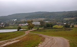
Holohory (Ukrainian: Гологори, Russian: Гологоры - Gologory, Polish: Gołogóry) is a hill range in the northwestern part of Podolian Upland, Ukraine, stretching from Lviv to Zolochiv, constituting part of the European watershed.[1] The name literally means "bare mountains".[2]
References
Wikimedia Commons has media related to Holohory.
- ^ "Gołogóry" in Słownik geograficzny Królestwa Polskiego i innych krajów słowiańskich (Geographical Dictionary of the Kingdom of Poland). — Warszaw, 1881, Vol. II : Derenek — Gżac, p. 675.
- ^ "Gołogóry", by Sadok Barącz, in: ''Smotrycki Melecy: szkic bibliograficzny, Poznań, 1889, pp.1-9.
- v
- t
- e
Geographic regions of Ukraine
Geography of Ukraine
East
European
Plain
European
Plain
| Volhynian Upland |
|
|---|---|
| Podolian Upland |
|
| Dnieper Upland |
|
| Polesian Lowland |
|
| Sian–Dniester Plain |
|
| Small Polesia Plain |
|
| Other plains |
|
Carpathians
| Eastern Carpathian Foothills |
|
|---|
| Authority control databases |
|
|---|
 | This article about a location in Ukraine is a stub. You can help Wikipedia by expanding it. |
- v
- t
- e


