Florida Mountains
Mountain range in New Mexico, United States


Florida Mountains
Florida Mountains
in New Mexico
in New Mexico
West Potrillo Mountains-E
Cedar Mountain Range-WSW
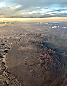

The Florida Mountains are a small 12-mile (19 km) long,[1] mountain range in New Mexico. The mountains lie in southern Luna County about 15 miles (24 km) southeast of Deming, and 20 miles (32 km) north of the state of Chihuahua, Mexico; the range lies in the north of the Chihuahuan Desert region, and extreme southwestern New Mexico.
The Florida Mountains are east and adjacent to New Mexico State Road 11, the north–south route to Chihuahua; it becomes Highway 23 in Chihuahua and connects to Mexican Federal Highway 2, the major east–west route of the north Chihuahuan Desert adjacent the U.S.-Mexico border.
Description
The Florida Mountains are a small, compact range about 12 miles (19 km) long, with various peaks from 5,000 to 7,000 feet (1,524 to 2,134 m). The range highpoint is Florida Peak, 7,295 feet (2,224 m),[2] which lies near the north. Other high peaks in the center-south, are Gym, Baldy, and South Peak. Four other peaks are in the extreme northwest; besides Florida Peak, the tallest of the other four is Capitol Dome, at 5,962 feet (1,817 m).
Most of the land surrounding the prominent rise of the mountain range are flatlands. Deming, and its suburbs directly south, form the northwest and west border of the range's minor foothills. Populated flatlands are northeast, with open flatlands to the east and southeast.
New Mexico 198 lies at the range's north, the location of Rockhound State Park. The park is nestled between the Florida Mountains, and a 3-mile (5 km) long mountain range called the Little Florida Mountains.
Environment and ecology
Persian (Bezoar) Ibex (Capra aegagrus aegagrus) have been introduced into the region, and have an established population.[3]
See also
References
External links
Peaks
- Florida Peak, trails.com
- v
- t
- e
- Black Mountain (Catron County)
- McKnight Mountain
- Cerro Grande
- Chicoma Mountain
- Redondo Peak
- South Baldy
- Pyramid Peak
(Cibola County)
- Mount Taylor
- West Blue Mountain
| Manzano Mountains | |
|---|---|
| Sandia Mountains |
| Cimarron Range |
|
|---|---|
| Taos Mountains |
|
| Others |
|
- Haystack Mountain
- Mount Sedgwick
- Aden Crater
- Alamo Hueco Mountains
- Animas Mountains
- Brazos Mountains
- Caballo Mountains
- Canjilón Mountain
- Canyon Creek Mountains
- Capitan Mountains
- Capulin Peak
- Cedar Mountain Range
- Datil Mountains
- Dirty Point
- Doña Ana Mountains
- Eagle Peak
- East Potrillo Mountains
- Elephant Butte (Hidalgo County)
- Elephant Butte (Sierra County)
- Fajada Butte
- Florida Mountains
- Franklin Mountains
- Granite Peak
- Guadalupe Mountains
- Guadalupe Mountains (Hidalgo County)
- Hosta Butte
- Hueco Mountains
- Huérfano Mountain
- Jicarilla Mountains
- Jornada del Muerto Volcano
- Ladron Peak
- Little Burro Mountains
- Little Hatchet Mountains
- Little San Pascual Mountain
- Luera Mountains
- Sierra Nacimiento
- Ocate Peak
- Ortiz Mountains
- Picacho Mountain
- Robledo Mountains
- San Antonio Mountain
- San Mateo Mountains (Socorro County)
- Sierra Aguilada
- Sierra Blanca
- Sierra de las Uvas
- West Potrillo Mountains
Authority control databases | |
|---|---|
| International |
|
| National |
|
 | This New Mexico state location article is a stub. You can help Wikipedia by expanding it. |
- v
- t
- e


