Dogbo
Town and sub-prefecture in Bas-Sassandra, Ivory Coast
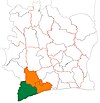
4°57′N 7°3′W / 4.950°N 7.050°W / 4.950; -7.050 Ivory Coast
 (2014)[1]
Dogbo is a town in south-western Ivory Coast. It is a sub-prefecture of San-Pédro Department in San-Pédro Region, Bas-Sassandra District.
The far northern part of the sub-prefecture lies within Taï National Park.
Dogbo was a commune until March 2012, when it became one of 1126 communes nationwide that were abolished.[2] In 2014, the population of the sub-prefecture of Dogbo was 37,391.[3]
Villages
The seven villages of the sub-prefecture of Dogbo and their population in 2014 are:[3]
- Bloho (1 797)
- Boua (4 056)
- Dogbo (8 634)
- Gléré (3 536)
- Gnépasso (12 216)
- Magnery (6 021)
- Mana (1131)
References
- ^ "Côte d'Ivoire". geohive.com. Retrieved 8 December 2015.
- ^ "Le gouvernement ivoirien supprime 1126 communes, et maintient 197 pour renforcer sa politique de décentralisation en cours", news.abidjan.net, 7 March 2012.
- ^ a b "RGPH 2014, Répertoire des localités, Région San-Pédro" (PDF). ins.ci. Retrieved 5 August 2019.
- v
- t
- e
Departments and sub-prefectures of San-Pédro Region, Bas-Sassandra DistrictRegional seat: San-Pédro
- Doba
- Dogbo
- Gabiadji
- Grand-Béréby*
- San-Pédro*
* also a commune
 | This Bas-Sassandra District location article is a stub. You can help Wikipedia by expanding it. |
- v
- t
- e


