Bourra
Commune in Gao Region, Mali
15°28′25″N 0°42′35″E / 15.47361°N 0.70972°E / 15.47361; 0.70972 Mali
Mali (2009 census)[2]
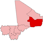
Bourra is a commune in the Cercle of Ansongo in the Gao Region of south-eastern Mali. The commune extends along the left (east) bank of the River Niger. It covers an area of approximately 2,323 square kilometers and includes 14 villages. In the 2009 census the commune had a population of 19,163.[2] The main village (chef-lieu) is Tassiga.
References
- ^ Common and Fundamental Operational Datasets Registry: Mali, United Nations Office for the Coordination of Humanitarian Affairs, archived from the original on 2012-12-14. commune_mali.zip (Originally from the Direction Nationale des Collectivités Territoriales, Mali)
- ^ a b Resultats Provisoires RGPH 2009 (Région de Gao) (PDF) (in French), République de Mali: Institut National de la Statistique, archived from the original (PDF) on 2011-07-22.
External links
- Plan de Sécurite Alimentaire Commune Rurale de Bourra 2005-2009 (PDF) (in French), Commissariat à la Sécurité Alimentaire, République du Mali, USAID-Mali, 2005, archived from the original (PDF) on 2011-09-06, retrieved 2011-02-08.
 | This Gao Region location article is a stub. You can help Wikipedia by expanding it. |
- v
- t
- e


