Liste der Einträge im National Register of Historic Places im Cooper County
Die Liste der Einträge im National Register of Historic Places im Cooper County in Missouri führt die Bauwerke und historischen Stätten im Cooper County auf, die in das National Register of Historic Places aufgenommen wurden.[1][2]
Legende
| NRHP | Historic Place |
|---|---|
| HD | Historic District |
Aktuelle Einträge
| [3] | Name[4] | Bild | Eintragsdatum | Lage | Ort | Beschreibung |
|---|---|---|---|---|---|---|
| 1 | Andrews-Wing House |  | 1990 ID-Nr. 82005304 | 733 Main Street 38° 58′ 17″ N, 92° 44′ 33″ W38.971389-92.7425 | Boonville | |
| 2 | Arrow Rock | 1966 ID-Nr. 66000422 | Arrow Rock State Park 39° 4′ 0″ N, 92° 56′ 41″ W39.066667-92.944722 | südlich von Arrow Rock | ||
| 3 | William S. and Mary Beckett House |  | 1990 ID-Nr. 82005288 | 821 3rd Street 38° 58′ 8″ N, 92° 44′ 43″ W38.968889-92.745278 | Boonville | |
| 4 | Blackwater Commercial Historic District | 2005 ID-Nr. 04001520 | 118,120 und 122 Main Street 38° 58′ 57″ N, 92° 59′ 26″ W38.9825-92.990556 | Blackwater | ||
| 5 | Blackwater Residential Historic District | 2009 ID-Nr. 09000597 | Teile der Blöcke 300 und 400 der Trigg Avenue, des Blocks 300 der Scott Avenue sowie des Blocks 300 der Main Street 38° 58′ 49,1″ N, 92° 59′ 27,5″ W38.980317-92.990983 | Blackwater | ||
| 6 | Albert Gallatin Blakey House |  | 1990 ID-Nr. 82005289 | 226 West Spring Street 38° 58′ 24″ N, 92° 45′ 10″ W38.973333-92.752778 | Boonville | |
| 7 | Boller House | 1977 ID-Nr. 77000803 | 223 East Spring Street 38° 58′ 30″ N, 92° 44′ 50″ W38.975-92.747222 | Boonville | Zerstört[2] | |
| 8 | Cobblestone Street |  | 1990 ID-Nr. 82005293 | 100 Main Street 38° 58′ 41″ N, 92° 44′ 40″ W38.978056-92.744444 | Boonville | |
| 9 | John S. Dauwalter House | 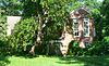 | 1990 ID-Nr. 82005296 | 817 7th Street 38° 58′ 11″ N, 92° 44′ 20″ W38.969722-92.738889 | Boonville | |
| 10 | Dick-Kobel Homestead | 1982 ID-Nr. 82003133 | Westlich von Jamestown 38° 44′ 48″ N, 92° 35′ 33″ W38.746667-92.5925 | Jamestown | ||
| 11 | Duke and Mary Diggs House |  | 1990 ID-Nr. 82005297 | 1217 Rural Street 38° 58′ 48″ N, 92° 43′ 59″ W38.98-92.733056 | Boonville | |
| 12 | Fessler-Secongost House | 1990 ID-Nr. 82005335 | 119 West Morgan Street 38° 58′ 32″ N, 92° 45′ 2″ W38.975556-92.750556 | Boonville | ||
| 13 | Andrew Gantner House | 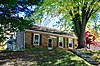 | 1990 ID-Nr. 82005303 | 1308 6th Street 38° 57′ 52″ N, 92° 44′ 18″ W38.964444-92.738333 | Boonville | |
| 14 | Hamilton-Brown Shoe Company Building | 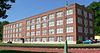 | 1990 ID-Nr. 82005305 | 1st Street 38° 58′ 29″ N, 92° 45′ 0″ W38.974722-92.75 | Boonville | |
| 15 | Harley Park Archeological Site | 1970 ID-Nr. 70000329 | Adresse nicht veröffentlicht | Boonville | ||
| 16 | Historic District A | 1983 ID-Nr. 83000979 | Vine Street und 2nd Street 38° 58′ 15″ N, 92° 44′ 48″ W38.970833-92.746667 | Boonville | ||
| 17 | Historic District B | 1983 ID-Nr. 83000980 | 4th Street und East Spring Street 38° 58′ 26″ N, 92° 44′ 40″ W38.973889-92.744444 | Boonville | ||
| 18 | Historic District C | 1983 ID-Nr. 83000981 | East High Street und 4th Street 38° 58′ 33″ N, 92° 44′ 48″ W38.975833-92.746667 | Boonville | ||
| 19 | Historic District D |  | 1983 ID-Nr. 83000982 | High Street und Main Street 38° 58′ 32″ N, 92° 44′ 37″ W38.975556-92.743611 | Boonville | |
| 20 | Historic District E | 1983 ID-Nr. 83000983 | High Street, Spring Street und Morgan Street 38° 58′ 38″ N, 92° 44′ 25″ W38.977222-92.740278 | Boonville | ||
| 21 | Historic District F | 1983 ID-Nr. 83000984 | 6th Street und 7th Street 38° 58′ 20″ N, 92° 44′ 24″ W38.972222-92.74 | Boonville | ||
| 22 | Historic District H | 1983 ID-Nr. 83000985 | East Morgan Street und Reformatory Drive 38° 58′ 35″ N, 92° 43′ 50″ W38.976389-92.730556 | Boonville | ||
| 23 | Imhoff Archeological Site | 1972 ID-Nr. 72000710 | Adresse nicht veröffentlicht | Blackwater | ||
| 24 | Juliet Trigg Johnson House |  | 1990 ID-Nr. 82005327 | 1304 Main Street 38° 57′ 50″ N, 92° 44′ 24″ W38.963889-92.74 | Boonville | |
| 25 | Wilbur T. and Rhoda Stephens Johnson House | 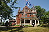 | 1990 ID-Nr. 82005322 | 821 Main Street 38° 58′ 12″ N, 92° 43′ 50″ W38.97-92.730556 | Boonville | |
| 26 | Lyric Theater |  | 1969 ID-Nr. 69000097 | Main Street Ecke Vine Street 38° 58′ 26″ N, 92° 44′ 33″ W38.973889-92.7425 | Boonville | |
| 27 | Meierhoffer House | 1990 ID-Nr. 82005317 | 120 East High Street 38° 58′ 34″ N, 92° 45′ 1″ W38.976111-92.750278 | Boonville | ||
| 28 | Meierhoffer Sand Company Office Building |  | 1990 ID-Nr. 82005318 | 201 2nd Street 38° 58′ 33″ N, 92° 45′ 1″ W38.975833-92.750278 | Boonville | |
| 29 | Mellor Village and Mounds Archeological District | 1969 ID-Nr. 69000098 | Adresse nicht veröffentlicht | Lamine | Im Jahr 1974 erweitert | |
| 30 | Missouri, Kansas and Texas Railroad Depot |  | 1990 ID-Nr. 82005312 | 320 1st Street 38° 58′ 30″ N, 92° 44′ 57″ W38.975-92.749167 | Boonville | |
| 31 | Morton-Myer House |  | 1990 ID-Nr. 82005316 | 1000 11th Street 38° 58′ 10″ N, 92° 43′ 51″ W38.969444-92.730833 | Boonville | |
| 32 | Mount Nebo Baptist Church | 1986 ID-Nr. 86001111 | MO 135/E 38° 48′ 12″ N, 92° 53′ 22″ W38.803333-92.889444 | Pilot Grove | ||
| 33 | Thomas Nelson House |  | 1990 ID-Nr. 82005302 | 700 10th Street 38° 58′ 26″ N, 92° 44′ 5″ W38.973889-92.734722 | Boonville | |
| 34 | New Lebanon Cumberland Presbyterian Church and School | 1979 ID-Nr. 79001359 | MO A 38° 45′ 53″ N, 92° 56′ 20″ W38.764722-92.938889 | New Lebanon | ||
| 35 | New Lebanon Historic District | 1998 ID-Nr. 98000597 | Westlich und südwestlich von MO A und New Lebanon Loop 38° 46′ 28″ N, 92° 56′ 21″ W38.774444-92.939167 | New Lebanon | ||
| 36 | Josephine Trigg Pigott House |  | 1990 ID-Nr. 82005328 | 1307 6th Street 38° 57′ 51″ N, 92° 44′ 20″ W38.964167-92.738889 | Boonville | |
| 37 | Pleasant Green | 1977 ID-Nr. 77000804 | Rund 13 km südwestlich von Pilot Grove am US 135 38° 48′ 11″ N, 92° 59′ 15″ W38.803056-92.9875 | Pilot Grove | ||
| 38 | Prairie View |  | 1982 ID-Nr. 82003134 | Östlich von Pleasant Green abseits der MO 135 38° 47′ 36″ N, 92° 55′ 51″ W38.793333-92.930833 | Pleasant Green | |
| 39 | Ravenswood |  | 1975 ID-Nr. 75001065 | Nordwestlich von Bunceton an der MO 5 38° 49′ 19″ N, 92° 50′ 17″ W38.821944-92.838056 | Bunceton | |
| 40 | Roeschel-Toennes-Oswald Property |  | 1983 ID-Nr. 83000986 | 515 West Spring Street 38° 58′ 21″ N, 92° 45′ 21″ W38.9725-92.755833 | Boonville | |
| 41 | St. Matthew's Chapel A.M.E. Church |  | 1990 ID-Nr. 82005324 | 309 Spruce Street 38° 58′ 14″ N, 92° 44′ 40″ W38.970556-92.744444 | Boonville | |
| 42 | Summer Public School |  | 1990 ID-Nr. 82005331 | 321 Spruce Street 38° 58′ 14″ N, 92° 44′ 38″ W38.970556-92.743889 | Boonville | |
| 43 | Wooldridge Archeological Site | 1970 ID-Nr. 70000330 | Adresse nicht veröffentlicht | Wooldridge |
Siehe auch
Einzelnachweise
- ↑ Auszug aus dem National Register of Historic Places - Cooper County Abgerufen am 21. Oktober 2012
- ↑ a b Originals vom 5. April 2012 im Internet Archive) Info: Der Archivlink wurde automatisch eingesetzt und noch nicht geprüft. Bitte prüfe Original- und Archivlink gemäß Anleitung und entferne dann diesen Hinweis.@1@2Vorlage:Webachiv/IABot/www.dnr.mo.gov Abgerufen am 21. Oktober 2012
- ↑ Die Nummerierung in dieser Listenspalte ist an der vom National Park Service vorgelegten Reihenfolge der Einträge orientiert; die Farben unterscheiden verschiedene Schutzgebietstypen des Nationalparksystems mit landesweiter Bedeutung (z. B. National Historic Landmarks) von den sonstigen Einträgen im National Register of Historic Places.
- ↑ National Register Information System. In: National Register of Historic Places. National Park Service, abgerufen am 9. Juli 2010 (englisch).

- Karte mit allen Koordinaten:
- OSM
- WikiMap

Einträge im National Register of Historic Places in Missouri
National Register of Historic Places in Missouri
Adair | Andrew | Atchison | Audrain | Barry | Barton | Bates | Benton | Bollinger | Boone | Buchanan | Butler | Caldwell | Callaway | Camden | Cape Girardeau | Carroll | Carter | Cass | Cedar | Chariton | Christian | Clark | Clay | Clinton | Cole | Cooper | Crawford | Dade | Dallas | Daviess | DeKalb | Dent | Douglas | Dunklin | Franklin | Gasconade | Gentry | Greene | Grundy | Harrison | Henry | Hickory | Holt | Howard | Howell | Iron | Jackson | Jasper | Jefferson | Johnson | Knox | Laclede | Lafayette | Lawrence | Lewis | Lincoln | Linn | Livingston | Macon | Madison | Maries | Marion | McDonald | Mercer | Miller | Mississippi | Moniteau | Monroe | Montgomery | Morgan | New Madrid | Newton | Nodaway | Oregon | Osage | Ozark | Pemiscot | Perry | Pettis | Phelps | Pike | Platte | Polk | Pulaski | Putnam | Ralls | Randolph | Ray | Reynolds | Ripley | Saline | Schuyler | Scotland | Scott | Shannon | Shelby | St. Charles | St. Clair | St. Francois | St. Louis | St. Louis City | Ste. Genevieve | Stoddard | Stone | Sullivan | Taney | Texas | Vernon | Warren | Washington | Wayne | Webster | Worth | Wright


